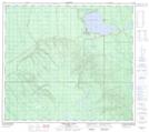
Maps showing Checker Lake, 5-86-7-W4, Alberta
Checker Lake is a Lake located in 5-86-7-W4, Alberta.
- Latitude: 56° 25' 49'' North (decimal: 56.4302777)
- Longitude: 111° 3' 55'' West (decimal: -111.0652778)
- Topography Feature Category: Lake
- Geographical Feature: Lake
- Canadian Province/Territory: Alberta
- Location: 5-86-7-W4
- Atlas of Canada Locator Map: Checker Lake
- GPS Coordinate Locator Map: Checker Lake Lat/Long
Checker Lake NTS Map Sheets