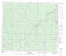
Maps showing Keeblo Hill, 12-66-6-W6, Alberta
Keeblo Hill is a Mountain located in 12-66-6-W6, Alberta.
- Latitude: 54° 41' 44'' North (decimal: 54.6955555)
- Longitude: 118° 46' 8'' West (decimal: -118.7688888)
- Topography Feature Category: Mountain
- Geographical Feature: Hill
- Canadian Province/Territory: Alberta
- Location: 12-66-6-W6
- Atlas of Canada Locator Map: Keeblo Hill
- GPS Coordinate Locator Map: Keeblo Hill Lat/Long
Keeblo Hill NTS Map Sheets