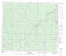
Maps showing Little Musreau Lake, 22-64-5-W6, Alberta
Little Musreau Lake is a Lake located in 22-64-5-W6, Alberta.
- Latitude: 54° 32' 51'' North (decimal: 54.5474999)
- Longitude: 118° 40' 4'' West (decimal: -118.6677778)
- Topography Feature Category: Lake
- Geographical Feature: Lake
- Canadian Province/Territory: Alberta
- Location: 22-64-5-W6
- Atlas of Canada Locator Map: Little Musreau Lake
- GPS Coordinate Locator Map: Little Musreau Lake Lat/Long
Little Musreau Lake NTS Map Sheets