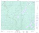
Maps showing Many Creeks, 16-74-12-W4, Alberta
Many Creeks is a River located in 16-74-12-W4, Alberta.
- Latitude: 55° 20' 55'' North (decimal: 55.3486110)
- Longitude: 111° 49' 33'' West (decimal: -111.8258332)
- Topography Feature Category: River
- Geographical Feature: Creek
- Canadian Province/Territory: Alberta
- Location: 16-74-12-W4
- Atlas of Canada Locator Map: Many Creeks
- GPS Coordinate Locator Map: Many Creeks Lat/Long
Many Creeks NTS Map Sheets