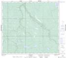
Maps showing Cheecham Creek, 9-18-84-5-W4, Alberta
Cheecham Creek is a River located in 9-18-84-5-W4, Alberta.
- Latitude: 56° 22' 3'' North (decimal: 56.3674999)
- Longitude: 110° 48' 56'' West (decimal: -110.8155560)
- Topography Feature Category: River
- Geographical Feature: Creek
- Canadian Province/Territory: Alberta
- Location: 9-18-84-5-W4
- Atlas of Canada Locator Map: Cheecham Creek
- GPS Coordinate Locator Map: Cheecham Creek Lat/Long
Cheecham Creek NTS Map Sheets