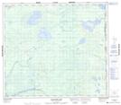
Maps showing South Watchusk Lake, 6-83-2-W4, Alberta
South Watchusk Lake is a Lake located in 6-83-2-W4, Alberta and has an elevation of 452 meters.
- Latitude: 56° 10' 19'' North (decimal: 56.1719444)
- Longitude: 110° 17' 45'' West (decimal: -110.2958332)
- Topography Feature Category: Lake
- Geographical Feature: Lake
- Canadian Province/Territory: Alberta
- Elevation: 452 meters
- Location: 6-83-2-W4
- Atlas of Canada Locator Map: South Watchusk Lake
- GPS Coordinate Locator Map: South Watchusk Lake Lat/Long
South Watchusk Lake NTS Map Sheets