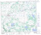
Maps showing Alexis 133, 10-55-4-W5, Alberta
Alexis 133 is a Indian Reserve located in 10-55-4-W5, Alberta.
- Latitude: 53° 44' North (decimal: 53.7333333)
- Longitude: 114° 29' West (decimal: -114.4833332)
- Topography Feature Category: Indian Reserve
- Geographical Feature: Indian Reserve - Réserve indienne
- Canadian Province/Territory: Alberta
- Location: 10-55-4-W5
- Atlas of Canada Locator Map: Alexis 133
- GPS Coordinate Locator Map: Alexis 133 Lat/Long
Alexis 133 NTS Map Sheets