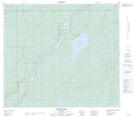
Maps showing Janvier 194, 16,17-80-5-W4, Alberta
Janvier 194 is a Indian Reserve located in 16,17-80-5-W4, Alberta.
- Latitude: 55° 56' 9'' North (decimal: 55.9358333)
- Longitude: 110° 43' 1'' West (decimal: -110.7169444)
- Topography Feature Category: Indian Reserve
- Geographical Feature: Indian Reserve - Réserve indienne
- Canadian Province/Territory: Alberta
- Location: 16,17-80-5-W4
- Atlas of Canada Locator Map: Janvier 194
- GPS Coordinate Locator Map: Janvier 194 Lat/Long
Janvier 194 NTS Map Sheets