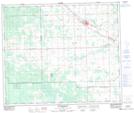
Maps showing Blue Quills First Nation, 11,14-58-10-W4, Alberta
Blue Quills First Nation is a Indian Reserve located in 11,14-58-10-W4, Alberta.
- Latitude: 53° 59' 55'' North (decimal: 53.9986111)
- Longitude: 111° 23' 24'' West (decimal: -111.3900000)
- Topography Feature Category: Indian Reserve
- Geographical Feature: Indian Reserve - Réserve indienne
- Canadian Province/Territory: Alberta
- Location: 11,14-58-10-W4
- Atlas of Canada Locator Map: Blue Quills First Nation
- GPS Coordinate Locator Map: Blue Quills First Nation Lat/Long
Blue Quills First Nation NTS Map Sheets