Maps showing The Gatekeeper, New Westminster Land District, British Columbia
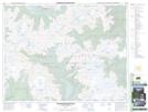
The Gatekeeper is a Mountain located in New Westminster Land District, British Columbia.
- Latitude: 49° 57' 13'' North (decimal: 49.9536111)
- Longitude: 122° 43' 51'' West (decimal: -122.7308333)
- Topography Feature Category: Mountain
- Geographical Feature: Peak
- Canadian Province/Territory: British Columbia
- Location: New Westminster Land District
- Atlas of Canada Locator Map: The Gatekeeper
- GPS Coordinate Locator Map: The Gatekeeper Lat/Long
The Gatekeeper NTS Map Sheets