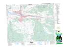
Maps showing McConnell Hill, Kamloops Division YaleLand District, British Columbia
McConnell Hill is a Mountain located in Kamloops Division YaleLand District, British Columbia and has an elevation of 1407 meters.
- Latitude: 50° 30' 25'' North (decimal: 50.5069444)
- Longitude: 120° 27' 2'' West (decimal: -120.450556)
- Topography Feature Category: Mountain
- Geographical Feature: Hill
- Canadian Province/Territory: British Columbia
- Elevation: 1407 meters
- Location: Kamloops Division YaleLand District
- Atlas of Canada Locator Map: McConnell Hill
- GPS Coordinate Locator Map: McConnell Hill Lat/Long