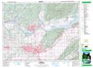
Maps showing Lonzo Creek, New Westminster Land District, British Columbia
Lonzo Creek is a River located in New Westminster Land District, British Columbia and has an elevation of 25 meters.
- Latitude: 49° 3' 27'' North (decimal: 49.0575000)
- Longitude: 122° 10' 45'' West (decimal: -122.1791999)
- Topography Feature Category: River
- Geographical Feature: Creek
- Canadian Province/Territory: British Columbia
- Elevation: 25 meters
- Location: New Westminster Land District
- GPS Coordinate Locator Map: Lonzo Creek Lat/Long