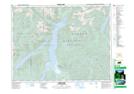
Maps showing Hector Ferguson Lake, New Westminster Land District, British Columbia
Hector Ferguson Lake is a Lake located in New Westminster Land District, British Columbia and has an elevation of 877 meters.
- Latitude: 49° 26' 22'' North (decimal: 49.4394444)
- Longitude: 122° 27' 15'' West (decimal: -122.4541666)
- Topography Feature Category: Lake
- Geographical Feature: Lake
- Canadian Province/Territory: British Columbia
- Elevation: 877 meters
- Location: New Westminster Land District
- Atlas of Canada Locator Map: Hector Ferguson Lake
- GPS Coordinate Locator Map: Hector Ferguson Lake Lat/Long
Hector Ferguson Lake NTS Map Sheets