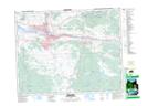
Maps showing Shumway Hill, Kamloops Division Yale Land District, British Columbia
Shumway Hill is a Mountain located in Kamloops Division Yale Land District, British Columbia and has an elevation of 1012 meters.
- Latitude: 50° 32' 31'' North (decimal: 50.5419444)
- Longitude: 120° 17' 29'' West (decimal: -120.291389)
- Topography Feature Category: Mountain
- Geographical Feature: Hill
- Canadian Province/Territory: British Columbia
- Elevation: 1012 meters
- Location: Kamloops Division Yale Land District
- Atlas of Canada Locator Map: Shumway Hill
- GPS Coordinate Locator Map: Shumway Hill Lat/Long