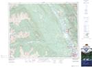
Maps showing Windermere, Kootenay Land District, British Columbia
Windermere is a Unincorporated area located in Kootenay Land District, British Columbia.
- Latitude: 50° 31' 2'' North (decimal: 50.5172222)
- Longitude: 116° 1' 46'' West (decimal: -116.029444)
- Topography Feature Category: Unincorporated area
- Geographical Feature: Railway Point
- Canadian Province/Territory: British Columbia
- Location: Kootenay Land District
- Atlas of Canada Locator Map: Windermere
- GPS Coordinate Locator Map: Windermere Lat/Long
Windermere NTS Map Sheets