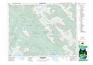
Maps showing Sklahhesten Indian Reserve 5B, New Westminster Land District, British Columbia
Sklahhesten Indian Reserve 5B is a Indian Reserve located in New Westminster Land District, British Columbia.
- Latitude: 49° 54' 26'' North (decimal: 49.9072222)
- Longitude: 122° 19' 16'' West (decimal: -122.321111)
- Topography Feature Category: Indian Reserve
- Geographical Feature: Indian Reserve
- Canadian Province/Territory: British Columbia
- Location: New Westminster Land District
- Atlas of Canada Locator Map: Sklahhesten Indian Reserve 5B
- GPS Coordinate Locator Map: Sklahhesten Indian Reserve 5B Lat/Long
Sklahhesten Indian Reserve 5B NTS Map Sheets