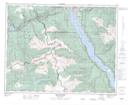
Maps showing Blanket Creek Recreation Area, Kootenay Land District, British Columbia
Blanket Creek Recreation Area is a Conservation area located in Kootenay Land District, British Columbia.
- Latitude: 50° 50' North (decimal: 50.8332999)
- Longitude: 118° 5' West (decimal: -118.0832999)
- Topography Feature Category: Conservation area
- Geographical Feature: Provincial Recreation Area
- Canadian Province/Territory: British Columbia
- Location: Kootenay Land District
- GPS Coordinate Locator Map: Blanket Creek Recreation Area Lat/Long