Canada Topographic Maps

Columbia System Topo Maps

Topography maps and Latitude/Longitude Location

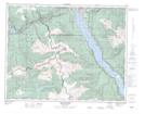
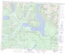
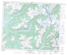
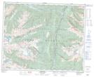
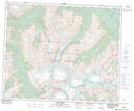
Maps showing Columbia System, Kootenay Land District, British Columbia

Columbia System is a Mountain located in Kootenay Land District, British Columbia.

  • Latitude: 51° 0' North   (decimal: 51.0000000)
  • Longitude: 118° 00' West   (decimal: -117.9999999)
  • Topography Feature Category: Mountain
  • Geographical Feature: Mountains
  • Canadian Province/Territory: British Columbia
  • Location: Kootenay Land District
  • GPS Coordinate Locator Map: Columbia System Lat/Long

Columbia System NTS Map Sheets

082L16 Revelstoke Topographic Map at 1:50,000 scale

083D04 Murtle Lake Topographic Map at 1:50,000 scale

083D05 Angus Horne Lake Topographic Map at 1:50,000 scale

083D06 Lempriere Topographic Map at 1:50,000 scale

083D13 Kiwa Creek Topographic Map at 1:50,000 scale

082L Vernon Topographic Map at 1:250,000 scale

083C Brazeau Lake Topographic Map at 1:250,000 scale

083D Canoe River Topographic Map at 1:250,000 scale

 
Buy Topographic Maps DVD
Newsletter Sign-up

Yes, I want to receive map store discounts.


Bookmark and Share