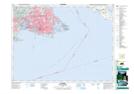
Maps showing Royal Point, Esquimalt Land District, British Columbia
Royal Point is a Cape located in Esquimalt Land District, British Columbia.
- Latitude: 48° 25' 10'' North (decimal: 48.4193999)
- Longitude: 123° 24' 50'' West (decimal: -123.4138999)
- Topography Feature Category: Cape
- Geographical Feature: Point
- Canadian Province/Territory: British Columbia
- Location: Esquimalt Land District
- Atlas of Canada Locator Map: Royal Point
- GPS Coordinate Locator Map: Royal Point Lat/Long
Royal Point NTS Map Sheets