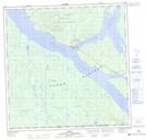
Maps showing Colwell Bay, Yukon
Colwell Bay is a Bay located in Yukon and has an elevation of 691 meters.
- Latitude: 60° 14' 15'' North (decimal: 60.2375)
- Longitude: 132° 31' 44'' West (decimal: -132.5288889)
- Topography Feature Category: Bay
- Geographical Feature: Bay
- Canadian Province/Territory: Yukon
- Elevation: 691 meters
- Atlas of Canada Locator Map: Colwell Bay
- GPS Coordinate Locator Map: Colwell Bay Lat/Long
Colwell Bay NTS Map Sheets