Canada Topographic Maps

Prévost River Topo Maps

Topography maps and Latitude/Longitude Location

Maps showing Prévost River, Yukon

Prévost River is a River located in Yukon.

  • Latitude: 62° 36' North   (decimal: 62.5999999)
  • Longitude: 131° 10' West   (decimal: -131.1666999)
  • Topography Feature Category: River
  • Geographical Feature: River
  • Canadian Province/Territory: Yukon
  • GPS Coordinate Locator Map: Prévost River Lat/Long

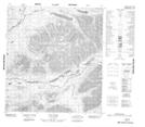
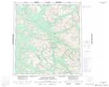
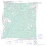
Prévost River NTS Map Sheets

105I13 Mount Wilson Topographic Map at 1:50,000 scale

105J09 No Title Topographic Map at 1:50,000 scale

105J10 No Title Topographic Map at 1:50,000 scale

105J11 Field Lake Topographic Map at 1:50,000 scale

105J16 Itsi Lakes Topographic Map at 1:50,000 scale

105I Little Nahanni River Topographic Map at 1:250,000 scale

105J Sheldon Lake Topographic Map at 1:250,000 scale

 
Buy Topographic Maps DVD
Newsletter Sign-up

Yes, I want to receive map store discounts.


Bookmark and Share