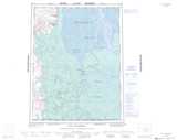
Maps showing Esau Channel, Mackenzie, Northwest Territories
Esau Channel is a Channel located in Mackenzie, Northwest Territories and has an elevation of 8 meters.
- Latitude: 68° 8' 25'' North (decimal: 68.1401463)
- Longitude: 134° 45' 34'' West (decimal: -134.7594732)
- Topography Feature Category: Channel
- Geographical Feature: Channel
- Canadian Province/Territory: Northwest Territories
- Elevation: 8 meters
- Location: Mackenzie
- Atlas of Canada Locator Map: Esau Channel
- GPS Coordinate Locator Map: Esau Channel Lat/Long
Esau Channel NTS Map Sheets