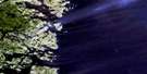
St Peter Bay Satellite Image Map
Download Free Aerial Photo 003D04 at 1:50,000 scale
St Peter Bay Satellite Imagery
To view this satellite map, mouse over the air photo on the right.
You can also download this satellite image map for free:
003D04 St Peter Bay high-resolution satellite image map.
Maps for the St Peter Bay aerial map sheet 003D04 at 1:50,000 scale are also available in these versions:
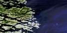
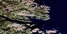
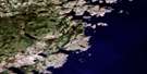
St Peter Bay Surrounding Area Aerial Photo Maps
 |
|||
 |
|||
 |
|||
 |
© Department of Natural Resources Canada. All rights reserved.
St Peter Bay Gazetteer
The following places can be found on satellite image map 003D04 St Peter Bay:
St Peter Bay Satellite Image: Bays
Ant Hill CoveAntelope Harbour
Antill Cove
Bad Bay
Camp Bay
Carrolls Cove
Cowhouse Cove
Dudee Cove
False Harbour
Frog Cove
Hauling Cove
Horn Bay
Islet Bay
Kennedy Bight
Niger Sound
Northeast Arm
Northwest Arm
Pitts Harbour
Pleasure Harbour
Schooner Cove
Shapes Harbour
Shoal Cove
Shoal Rock Cove
Simms Bay
Soldier Cove
South Pommelly Cove
Southwest Pond Cove
Spout Cove
St. Charles Harbour
St. Peter Bay
Temple Bay
The Lodge
Trouty Cove
White Bear Bay
Yankee Cove
St Peter Bay Satellite Image: Capes
Barrier PointBlack Head
Cape St. Charles
Elijah Point
Frog Cove Point
Grenville Point
Kennedy Head
Long Point
Loran Point
Ragged Point
Red Point
Rock Point
Salt Brook Point
Sandwich Point
Shoal Cove Point
Shoal Point
St. Peter Head
Symonds Head
Table Head
White Bear Point
White Point
St Peter Bay Satellite Image: Channels
Antelope TickleCaribou Run
Chimney Tickle
Détroit de Belle Isle
Long Island Tickle
Main Tickle
St. Charles Channel
Strait of Belle Isle
The Narrows
The Narrows
St Peter Bay Satellite Image: Islands
Battle IslandsBig Duck Island
Black Island
Camp Islands
Deer Island
Double Island
Double Island
Duck Island
Dumpling Island
Eastern Island
Flat Island
Fox Island
Fox Island
Goat Island
Great Caribou Island
Hare Island
Henley Island
Higgins Island
Little Duck Island
Muddle Island
Paddy Bonds Island
Peterel Islands
Red Island
Sandy Island
Seal Islands
Seal Islands
St. Charles Gull Island
St. Peter Islands
Tilcey Island
Truck Island
Wall Island
Western Island
St Peter Bay Satellite Image: Lakes
Barry Barnes PondBeaver Pond
Big Rabbit Pond
Black Hill Pond
Coopers Pond
Deer Pond
Deer Pond
Eddies Pond
First Deer Pond
Little Rabbit Pond
Lodge Pond
Outside Beaver Pond
Pea Soup Pond
Pins Pond
Pleasure Harbour Pond
Rabbit Ponds
Second Deer Pond
Sound Pond
Southwest Pond
Southwest Pond
St. Peters Gully
St. Peters Pond
Yankee Pond
St Peter Bay Satellite Image: Mountains
Ant HillBeacon Hill
Northwest Hill
Pitts Hill
Rabbit Ponds Hills
Saunders Knob
Souther Hill
St. Peters Hills
The Soldier
St Peter Bay Satellite Image: Rivers
Sound BrookSt. Charles River
St. Peters River
Temple Brook
Yankee Brook
St Peter Bay Satellite Image: Seas
Labrador SeaMer du Labrador
St Peter Bay Satellite Image: Shoals
Allen ShoalColes Bank
Duck Island Bank
Fish Rock
Fish Rock
Henny Bank
Indian Rocks
Inner Shoal
Kerry Ground
King Rocks
Middle Shoal
Morgan Shoal
Pound Rocks
Red Island Bank
Romsey Rock
Shoal Ground
St. Charles Gull Rocks
The Horns
Wall Shoal
Wells Rock
Western Bank
St Peter Bay Satellite Image: Unincorporated areas
Camp BayCape Charles
Carrolls Cove
Chimney Tickle
Lodge
Lodge Bay
Loran
Pitts Harbour

© Department of Natural Resources Canada. All rights reserved.
