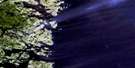
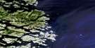
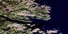
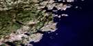
Francis Harbour Satellite Image Map
Download Free Aerial Photo 003D12 at 1:50,000 scale
Francis Harbour Satellite Imagery
To view this satellite map, mouse over the air photo on the right.
You can also download this satellite image map for free:
003D12 Francis Harbour high-resolution satellite image map.
Maps for the Francis Harbour aerial map sheet 003D12 at 1:50,000 scale are also available in these versions:
Francis Harbour Surrounding Area Aerial Photo Maps
 |
|||
 |
|||
 |
|||
 |
© Department of Natural Resources Canada. All rights reserved.
Francis Harbour Gazetteer
The following places can be found on satellite image map 003D12 Francis Harbour:
Francis Harbour Satellite Image: Bays
Alexis BayArch Cove
Backside of Hell Cove
Barnes Cove
Barns Cove
Bartlett Cove
Big Cove
Blackguard Bay
Blackguard Bight
Bobs Cove
Bowring Cove
Cape Cove
Caplin Bay
Clark Cove
Cogan Cove
Cole Cove
Crow Gulch
Crusty Cove
Deer Park
Delaney Cove
Fannys Cove
Fish Cove
Fox Cove
French Cove
George Cove
Georges Cove
Gilbert Bay
Good Cove
Green Cove
Green Cove
Hell Cove
Hole in the Wall Cove
Honeyfly Cove
Indian Bight
Island Cove
Island Harbour
Johnny Mews Cove
Kelpy Cove
Kennedy Cove
Kerry Cove
Lady Gulch
Lance Cove
Long Arm
Long Gulch
Melton Cove
Merchantman Harbour
Northwest Arm
Occasional Harbour
Pancake
Peckham Cove
Pigeon Gulches
Pinsent Arm
Red Bay
Redman Cove
Rexons Cove
Round Harbour
Round Harbour
Russell Cove
Schooner (Deep) Cove
Schooner Cove
Scrammy Bay
Ship Harbour
Ship Harbour
Sloop Cove
Southwest Bight
Square Island Harbour
St Francis Harbour Bight
St. Francis Harbour
St. Michaels Bay
Starvation Cove
Tabbeys Harbour
Tobys Harbour
Trout Cove
Watering Cove
Wells Cove
Wild Bight
Williams Harbour
Francis Harbour Satellite Image: Beaches
Burnell BeachFrancis Harbour Satellite Image: Capes
Back HeadBlack Head
Black Point
Bull Point
Cape St. Francis
Cape St. Michaels
Crowsnest
Dead Mans Point
Dickies Head
False Cape
First Point
Fox Cove Head
Georges Cove Head
Georges Cove Point
Green Cove Point
Halfway Point
Harbour Point
Hole in the Wall
Indian Point
Long Point
Main Cape
Man O'War Head
Mussel Cove Point
Mussel Point
Northern Head
Northern Head
Old Mans Head
Parsons Point
Point of the Bay
Point of the Island
Red Point
Red Point
Red Point
Redman Point
Rexons Point
Sailors Point
Salmon Point
Salmon Point
Salmon Point
Shinneys Point
Ship Harbour Head
Ship Harbour Head
Shoal Point
Shoal Point
Sleepy Point
Sloop Cove Head
Southern Point
Southern Point
Sunday Gulch Point
Swirlers Point
Terra Nova Point
The Bangers
Whaleback Point
White Point
Wild Bight Point
Francis Harbour Satellite Image: Channels
Ballast Island TickleBarns Cove Water
Bear Gulch
Blind Tickle
Boyeans Tickle
Cape Tickle
Captain Jacks Tickle
Georges Cove Run
Jersey Tickle
Main Tickle
Mungo Run
Muskrat Tickle
Northern Ships Run
Parsons Tickle
Pipers Tickle
Salmon Gulch
Ships Tickle
Shoal Tickle
Shoal Tickle
Taylor Tickle
Welshes Tickle
Williams Harbour Run
Williams Harbour Run
Winter Tickle
Francis Harbour Satellite Image: Islands
Ball IslandBallast Island
Big Island
Birchy Narrows Island
Bloody Bag Island
Bobby Duck Island
Bobs Island
Bold Island
Bottle Island
Bull Island
Burke Island
Burnt Island
Cartwright Island
Copper Island
Curlew Island
Deepwater Island
Denbigh Island
Duck Island
East Island
Fishing Islands
Flat Island
Goat Island
Granby Island
Hare Island
Jacket Island
Job Island
Juniper Island
Killey Island
Lazyman Island
Leg Island
Little Copper Island
Long (Fox) Island
Long Island
Long Island
Mercer Island
Middle Island
Mongo Islands
Motion Island
Narrows Island
Olive Stone Island
Otter Island
Pigeon Island
Pigeon Island
Pigeon Island
Pinsent Island
Raft Islet
Red Island
Rexons Island
Roundhill Island
Saddle Island
Sandy Cove Island
Sandy Island
Shinney Island
Ships Tickle Island
Skinny Island
Sodpy Island
Spratt Island
Square Island
Staring Island
Sub Islet
The Sisters
Twin Islands
West Island
Whitefish Island
Whitely Island
Wild Bight Island
Yellow Fox Island
Francis Harbour Satellite Image: Lakes
Beaver PondBig Pond
Big Pond
Long Pond
Sandy Pond
Francis Harbour Satellite Image: Mountains
Break-Heart HillRound Hill
Francis Harbour Satellite Image: Seas
Labrador SeaMer du Labrador
Francis Harbour Satellite Image: Shoals
Black RockCape Bank
Chain Rocks
Dickies Rocks
Fish Rock
Gull Rock
Hampton Bank
Harbour Rock
Mad Moll Rocks
Main Cape Bank
Offer Shoal
Pensons Rock
Pigeon Banks
Pigeon Island Rock
Red Island Shoal
Red Point Bank
Shinney Rock
The Chimney
The Cow
The Ribs
The Sinker
The Skerries
Francis Harbour Satellite Image: Unincorporated areas
Fishing Ships HarbourFrancis Harbour
Georges Cove
Kings Cove
Pensons Arm
Pinsents Arm
Rexons Cove
Sandy Hook
Square Islands
Williams Harbour

© Department of Natural Resources Canada. All rights reserved.
