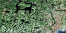
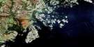
Lac Nesle Satellite Image Map
Download Free Aerial Photo 012J13 at 1:50,000 scale
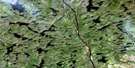
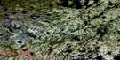
Lac Nesle Satellite Imagery
To view this satellite map, mouse over the air photo on the right.
You can also download this satellite image map for free:
012J13 Lac Nesle high-resolution satellite image map.
Maps for the Lac Nesle aerial map sheet 012J13 at 1:50,000 scale are also available in these versions:
Lac Nesle Surrounding Area Aerial Photo Maps
 |
 |
 |
|
 |
 |
 |
|
 |
|||
© Department of Natural Resources Canada. All rights reserved.
Lac Nesle Gazetteer
The following places can be found on satellite image map 012J13 Lac Nesle:
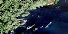
Lac Nesle Satellite Image: Lakes
Lac BlancLac Faride
Lac Henuku
Lac Kaiahinihkakamat
Lac Kaiatauetshimiskauhit
Lac Kakatshihip Niapaut
Lac Kapmitapiskat
Lac Katshistshekakamas
Lac Katshistshekakamat
Lac Kauatnaniskakamat
Lac Nesle
Lac Triquet
Lac Uepahkat
Lacs Atikuat Kanipaituht
Lacs Kaiatauiapekamut
Lac Nesle Satellite Image: Rapids
Rapides PahtapistnakanLac Nesle Satellite Image: Rivers
Rivière du Gros MécatinaRivière du Petit Mécatina
Rivière du Porc-Épic
Lac Nesle Satellite Image: Road features
Portage Henuku
© Department of Natural Resources Canada. All rights reserved.
