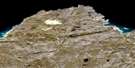
Cap De Nouvelle France Satellite Image Map
Download Free Aerial Photo 035I05 at 1:50,000 scale
Cap De Nouvelle France Satellite Imagery
To view this satellite map, mouse over the air photo on the right.
You can also download this satellite image map for free:
035I05 Cap De Nouvelle France high-resolution satellite image map.
Maps for the Cap De Nouvelle France aerial map sheet 035I05 at 1:50,000 scale are also available in these versions:
Cap De Nouvelle France Surrounding Area Aerial Photo Maps
 |
 |
||
 |
 |
 |
 |
© Department of Natural Resources Canada. All rights reserved.
Cap De Nouvelle France Gazetteer
The following places can be found on satellite image map 035I05 Cap De Nouvelle France:
Cap De Nouvelle France Satellite Image: Capes
Cap ButeuxCap de Nouvelle-France
Cap du Poly
Cap Weggs
Côte Akimmialuk
Cap De Nouvelle France Satellite Image: Channels
Détroit d'HudsonCap De Nouvelle France Satellite Image: Islands
Île KaattaituqCap De Nouvelle France Satellite Image: Lakes
Lac ArqutialuupCap De Nouvelle France Satellite Image: Rivers
Rivière HémardRivière Hengan
Ruisseau Tinujjaumavik
Cap De Nouvelle France Satellite Image: Valleys
Vallée Arqutialuk
© Department of Natural Resources Canada. All rights reserved.
