Cap De Nouvelle France Topo Map Online
Download Free Topo Map Sheet 035I05 at 1:50,000 scale
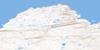
035I05 Cap De Nouvelle France Topo Map
To view this map, mouse over the map preview on the right.
You can also download this topo map for free:
035I05 Cap De Nouvelle France high-resolution topo map image.
Maps for the Cap De Nouvelle France topo map sheet 035I05 at 1:50,000 scale are also available in these versions:
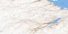
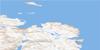
Cap De Nouvelle France Surrounding Area Topo Maps
 |
 |
||
 |
 |
 |
 |
© Department of Natural Resources Canada. All rights reserved.
Cap De Nouvelle France Gazetteer
The following places can be found on topographic map sheet 035I05 Cap De Nouvelle France:
Cap De Nouvelle France Topo Map: Capes
Cap ButeuxCap de Nouvelle-France
Cap du Poly
Cap Weggs
Côte Akimmialuk
Cap De Nouvelle France Topo Map: Channels
Détroit d'HudsonCap De Nouvelle France Topo Map: Islands
Île KaattaituqCap De Nouvelle France Topo Map: Lakes
Lac ArqutialuupCap De Nouvelle France Topo Map: Rivers
Rivière HémardRivière Hengan
Ruisseau Tinujjaumavik
Cap De Nouvelle France Topo Map: Valleys
Vallée Arqutialuk
© Department of Natural Resources Canada. All rights reserved.
