Snug Harbour Topo Map Online
Download Free Topo Map Sheet 003D13 at 1:50,000 scale
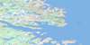
003D13 Snug Harbour Topo Map
To view this map, mouse over the map preview on the right.
You can also download this topo map for free:
003D13 Snug Harbour high-resolution topo map image.
Maps for the Snug Harbour topo map sheet 003D13 at 1:50,000 scale are also available in these versions:
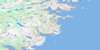
Snug Harbour Surrounding Area Topo Maps
 |
|||
 |
|||
 |
|||
 |
© Department of Natural Resources Canada. All rights reserved.
Snug Harbour Gazetteer
The following places can be found on topographic map sheet 003D13 Snug Harbour:
Snug Harbour Topo Map: Bays
Back CoveBar Cove
Break Heart Cove
Camels Cove
Cape Bluff Harbour
Cox Cove
Dead Islands Bay
Delaney Cove
Duck Harbour
Fortune Arm
Green Cove
Hambrook Cove
Harpers Cove
Hawke Bay
Herring Cove
Indian Cove
Island Harbour
Ladys Arm
Lord Arm
Martin Bay
New York Bay
New York Cove
Newtown Cove
Nowlan Harbour
Old Cove
Otter Bay
Pikes Cove
Red Island Cove
Round Harbour
Schooner Cove
Snappers Cove
Snug Harbour
Southwest Arm
St. Michaels Bay
Sugarloaf Cove
Tims Arm
Triangle Harbour
Trout Cove
Tub Harbour
Whitefish Cove
Wild Bight
Wild Bight
Wild Cove
Woody Cove
Snug Harbour Topo Map: Capes
Bar Cove HeadBrowns Neck
Cape Bluff
Cooper Head
Gun Point
Hamburg Head
Hawks Nest Point
Knowling Harbour Head
Knowling Point
Murray Point
Salmon Point
Seal Cove Head
Sloops Head
Southern Head
Standstill Point
Steves Point
Western Point
White Point
White Point
Snug Harbour Topo Map: Channels
Gambles TickleLewis Tickle
Long Tickle
Macy Tickle
Seal Cove
Shoal Tickle
The Wavers
Venison Tickle
Snug Harbour Topo Map: Islands
Bake Apple IslandBanger Island
Bar Tickle Island
Blubber Island
Bottle Island
Bull Island
Burn Island
Burnt Island
Butler Island
Camping Island
Canton Island
Carnabhus Island
Cliffty Island
Clifty Island
Cooper Island
Dark Tickle Island
Dead Islands
Deepwater Island
Deepwater Island
Double Island
Duck Island
Duck Island
Duck Islands
Eastern Island
Eddystone Island
Feltons Island
Flat Island
Flats Island
Fox Island
Goose Island
Gull Island
Gull Island
Gull Island
Gull Island
Iron Island
Jennifer Island
Jims Island
Juniper Island
Lewis Island
Little Gull Island
Macy Island
Mailmans Island
Meadow Island
North Island
Pigeon Island
Pigeon Island
Red Island
Sculpin Island
Seal Island
Seal Island
Ships Island
Square Island
Stony Island
Tinker Island
Venison Island
West Island
White Fox Island
White Islands
White Shot Island
Whitefish Island
Wild Bight Island
Wolf Islands
Woody Island
Snug Harbour Topo Map: Lakes
Bobs PondCape Bluff Pond
Coffee Pond
Cox Cove Pond
Gull Pond
Murphys Pond
New York Pond
Norman Bay Pond
Osberns Pond
Salt Pond
Salt Pond
Smitt Pond
Southwest Pond
Trout Cove Pond
Trout Pond
Wild Bight Pond
Snug Harbour Topo Map: Mountains
SugarloafSnug Harbour Topo Map: Seas
Labrador SeaMer du Labrador
Snug Harbour Topo Map: Shoals
Black RockBlack Rock
Cod Rock
Coopers Block
Greys Rock
Gull Rock
Gull Rock
Gun Rocks
Harbour Rock
Hen and Chickens
King
Mad Moll
Matthews Bank
Northward Rock
Queen
The Flats
The Rib
The Skelligs
The Skerries
Upper Rock
Snug Harbour Topo Map: Unincorporated areas
Dead IslandsNormans Bay
Norman's Bay
Snug Harbour
Triangle
Venison Islands

© Department of Natural Resources Canada. All rights reserved.
