Glace Bay Topo Map Online
Download Free Topo Map Sheet 011J04 at 1:50,000 scale
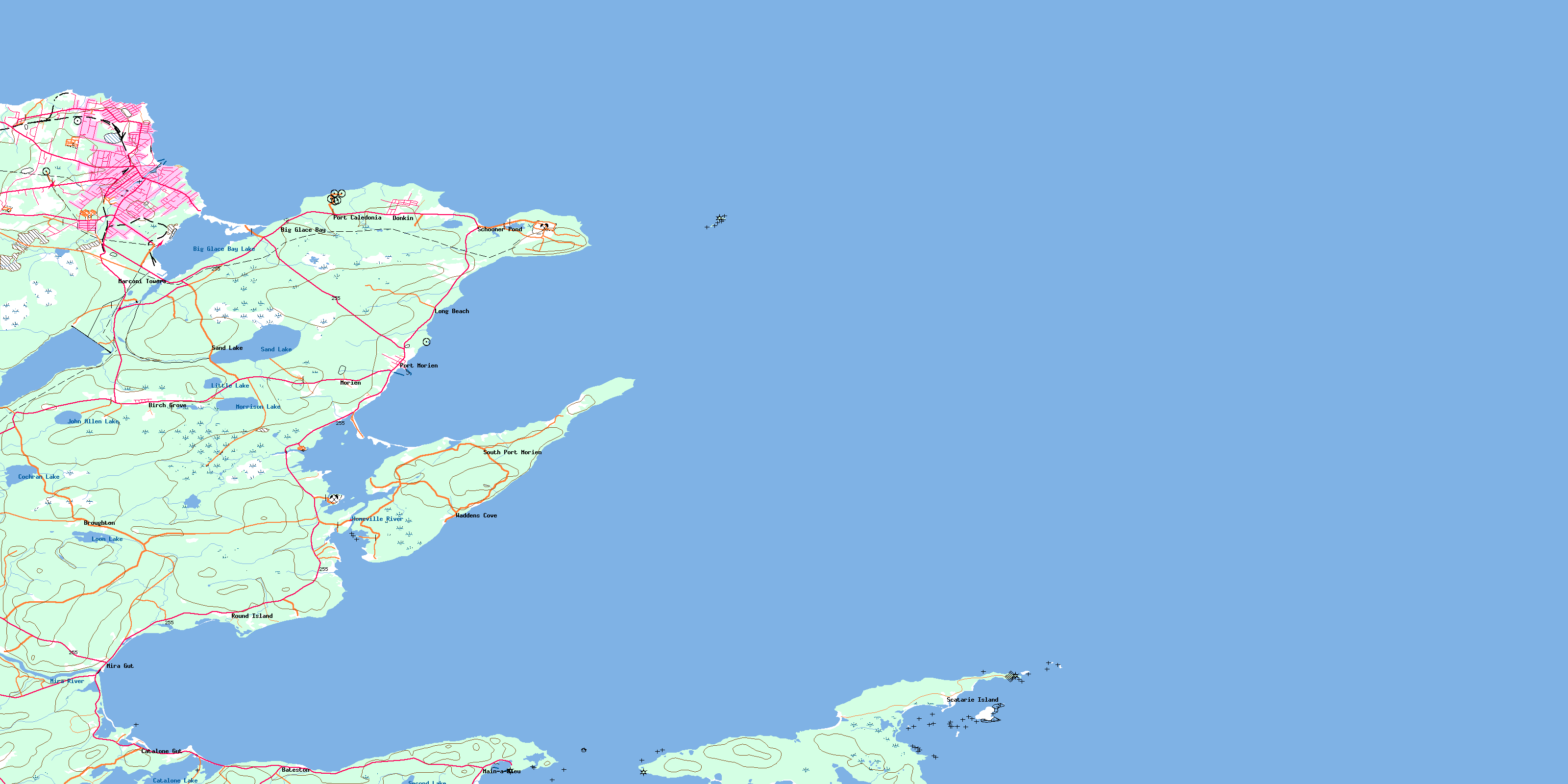
011J04 Glace Bay Topo Map
To view this map, mouse over the map preview on the right.
You can also download this topo map for free:
011J04 Glace Bay high-resolution topo map image.
Maps for the Glace Bay topo map sheet 011J04 at 1:50,000 scale are also available in these versions:
Glace Bay Surrounding Area Topo Maps
 |
© Department of Natural Resources Canada. All rights reserved.
Glace Bay Gazetteer
The following places can be found on topographic map sheet 011J04 Glace Bay:
Glace Bay Topo Map: Bays
Anchor CoveBack Cove
Baird Cove
Big Glace Bay
Bordens Cove
Bridgeport Cove
Campbells Cove
Cary Rocks Cove
Cow Bay
Deadman Cove
Deep Cove
Deep Water Cove
Eastern Harbour
False Bay
Fluke Cove
Flukes Head Cove
Glace Bay
Glace Bay
Glace Bay Harbour
Glace Bay Harbour
Goulds Cove
Grandfathers Cove
Hatchet Rock Cove
Howards Cove
Jimmys Cove
Little Goulds Cove
Long Cove
MacDonald Cove
Macdonald Cove
Mackerel Cove
Mainadieu Bay
Main-à-Dieu Bay
Mainadieu Harbour
Main-à-Dieu Harbour
Millbrook Cove
Mira Bay
Morien Bay
Neal Cove
Northwest Cove
Pigeon Head Cove
Port Caledonia
Ragged Rocks Cove
Round Island Cove
Savage Cove
Schooner Cove
Schooner Pond Cove
Seal Rock Cove
Shallop Cove
Spencers Creek
Tin Cove
Wadden Cove
Waddens Cove
Wallaces Cove
Western Point Cove
Glace Bay Topo Map: Beaches
Catalone BeachFalse Bay Beach
Glace Bay Beach
Hatchs Rock Breaker
Long Beach
Mira Beach
Phalens Bar
Glace Bay Topo Map: Capes
Arnold PointBattery Point
Blockhouse Point
Bordens Head
Burke Point
Burkes Point
Burnt Head
Campbell Point
Campbells Point
Cap Percé
Cape Morien
Cape Percé
Catalogne Point
Catalone Point
Coalhole Point
Eastern Head
False Bay Head
Flukes Head
Friar Point
Grandfathers Head
Gull Cape
Howe Point
Hub Head
Kellys Head
Lobster Point
MacAuleys Point
MacKeigans Point
Macpherson Point
MacRae Point
Macrae Point
Middle Point
Moque Head
Noneck Point
Northern Head
Northern Head
O'Neils Point
Pigeon Head
Quarry Point
Rock Point
Round Island Point
Savage Cove Head
Schooner Pond Head
South Head
South Head
Spencers Point
Steering Hummock
Table Head
Tin Cove Head
West Point
Western Point
Whelan Point
Winging Point
Wreck Point
Glace Bay Topo Map: Channels
Mainadieu PassageMain-à-Dieu Passage
Mira Gut
Glace Bay Topo Map: Cliffs
Northwestern BankGlace Bay Topo Map: Geographical areas
Cape BretonGlace Bay Topo Map: Islands
Brown IslandsCape Breton Island
Flint Island
Flint Islands
Fox Island
Hay Island
Île du Cap-Breton
Red Islet
Scatari Island
Scatarie Island
Glace Bay Topo Map: Lakes
Beaver PondBeaverdam Pond
Big Glace Bay Lake
Big Glace Lake
Campbell Pond
Catalogne Lake
Catalone Lake
Cochran Lake
Crow Pond
Dixons Pond
Dyson Pond
False Bay Lake
Fergusons Pond
Hall Pond
Halls Pond
Holmes Pond
John Allen Lake
Little Lake
Long Pond
Loon Lake
MacDonalds Pond
MacKeigans Ponds
Mackenzies Pond
MacLean Barachois
MacVicars Pond
McDonald Pond
McVicker Pond
Morrison Lake
Sand Lake
Schooner Pond
Second Lake
Tank Pond
Glace Bay Topo Map: Mountains
Buckleys HillFergusons Hill
The Pinnacle
Glace Bay Topo Map: Major municipal/district area - major agglomerations
Cape BretonGlace Bay Topo Map: Conservation areas
Big Glace Bay Lake Bird SanctuaryLieu historique national du Canada Marconi
Marconi National Historic Site of Canada
Refuge d'oiseaux du Big Glace Bay
Scatarie Island Wildlife Management Area
Glace Bay Topo Map: Rivers
Black BrookBlack Brook Morien
Blackwater Brook
Cadegan Brook
Cadogan Brook
Doctors Brook
Fergusons Brook
Henry Brook
Homeville River
Hughies Brook
Long Swamp Brook
MacAskills Brook
MacIntyre Brook
MacVicars Brook
McAskill Brook
McIntyre Brook
Mill Stream
Mira River
Morrison Brook
Renwick Brook
Sand Lake Brook
Spencer Creek
Spencer Creek
Spencers Brook
Spencers Brook
Glace Bay Topo Map: Shoals
Cary RocksCormorandière Rocks
Cow Reef
Duck Rock
Duck Rocks
Glace Bay Bar
Glace Bay Shoals
Great Shag Rock
Hall Rock
Halls Rock
Harbour Rock
Harbour Rock Shoals
Hatch Rocks
Hatchet Rocks
Hatchs Rocks
Little Shag Rock
Mad Dick Rock
Middle Rock
Middle Shoal
Nearings Rock
Neering Rock
Number One-B Reef
Red Rock
Schooner Rock
Shag Shoal
Wattie Rock
Glace Bay Topo Map: Unincorporated areas
BatestonBelloni
Big Glace Bay
Birch Grove
Bridgeport
Broughton
Caledonia
Caledonia Junction
Caledonia Mines
Catalogne Gut
Catalone Gut
Cochran Lake
Dixon
Dixons
Dominion No. 6
Donkin
East Slope
Glace Bay
Homeville
Hub
Long Beach
Mainadieu
Main-à-Dieu
Marconi
Marconi Towers
McKay Corners
McKays Corner
McLeods Crossing
Mira
Mira Gut
Morien
Morien Hill
Morien Junction
New Aberdeen
Passchendaele
Port Caledonia
Port Morien
Round Island
Sand Lake
Scatari Island
Scatarie Island
Schooner Pond
South Port Morien
Steeles Hill
Sterling
Table Head
Wadden Cove
Waddens Cove
Glace Bay Topo Map: Low vegetation
Black Brook MeadowsThe Bog
© Department of Natural Resources Canada. All rights reserved.
