Port Clements Topo Map Online
Download Free Topo Map Sheet 103F09 at 1:50,000 scale
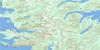
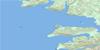
103F09 Port Clements Topo Map
To view this map, mouse over the map preview on the right.
You can also download this topo map for free:
103F09 Port Clements high-resolution topo map image.
Maps for the Port Clements topo map sheet 103F09 at 1:50,000 scale are also available in these versions:
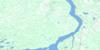
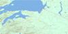
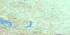
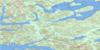
Port Clements Surrounding Area Topo Maps
 |
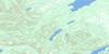 |
 |
|
 |
 |
||
 |
 |
||
 |
 |
© Department of Natural Resources Canada. All rights reserved.
Port Clements Gazetteer
The following places can be found on topographic map sheet 103F09 Port Clements:
Port Clements Topo Map: Bays
Buckley CoveCowhoe Bay
Ferguson Bay
Juskatla Inlet
Kumdis Bay
Mamin Bay
Masset Inlet
Shannon Bay
Stewart Bay
Stilique Bay
Yakoun Bay
Yestalton Bay
Port Clements Topo Map: Capes
Echinus PointMakai Point
Martin Point
Parker Point
Strathdang Kwun
Port Clements Topo Map: Channels
Juskatla NarrowsMasset Sound
Port Clements Topo Map: Indian Reserves
Ain Indian Reserve 6Lanas Indian Reserve 4
Mammin River Indian Reserve 25
Réserve indienne Ain 6
Réserve indienne Lanas 4
Réserve indienne Mammin River 25
Réserve indienne Satunquin 5
Satunquin Indian Reserve 5
Port Clements Topo Map: Islands
Cowley IslandsDawson Islands
Deasy Island
Fraser Island
Graham Island
Gray Island
Harrison Island
Harrison Islands
Îles de la Reine-Charlotte
Kumdis Island
Kwaikans Island
Learmonth Island
Mamin Islets
McCreight Island
Modeets Islands
Ohala Islets
Powell Island
Queen Charlotte Islands
Richards Island
Ross Island
Ross Islet
Ross Islets
Seegay Islets
Simpson Island
Smyth Island
Steilta Islets
Wathus Island
Wharton Island
Wiah Island
Port Clements Topo Map: Lakes
Bird LakeCollinson Lake
Hickey Lake
Little Lake
Loon Lake
Mayer Lake
New Year Lake
Pam Lake
Paul Lake
Port Clements Topo Map: Mountains
Juskatla MountainMcKay Range
Mount Begbie
Queen Charlotte Mountains
Towustasin Hill
Port Clements Topo Map: Conservation areas
Naikoon ParkPort Clements Topo Map: Plains
Skidegate PlateauPort Clements Topo Map: Rivers
Ain RiverBlackbear Creek
Blackwater Creek
Canoe Creek
Canyon Creek
Cohoe Creek
Copp Creek
Datlamen Creek
Florence Creek
Gold Creek
Gosse Creek
Hoodoo Creek
Kumdis Creek
Log Creek
Mamin River
Mayer River
Tlell River
Yakoun River
Port Clements Topo Map: River features
Kumdis SloughPort Clements Topo Map: Shoals
Borrowman ShoalsCowley Rock
Harrison Reef
Koutz Rock
Mackie Rock
McCreight Rock
Sinclair Rock
Stubbs Rock
Port Clements Topo Map: Unincorporated areas
JuskatlaShannon Bay
Port Clements Topo Map: Villages
Port Clements
© Department of Natural Resources Canada. All rights reserved.
