White Pass Topo Map Online
Download Free Topo Map Sheet 104M11 at 1:50,000 scale
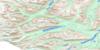
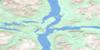
104M11 White Pass Topo Map
To view this map, mouse over the map preview on the right.
You can also download this topo map for free:
104M11 White Pass high-resolution topo map image.
Maps for the White Pass topo map sheet 104M11 at 1:50,000 scale are also available in these versions:
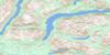
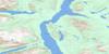
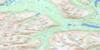
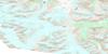
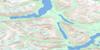
White Pass Surrounding Area Topo Maps
 |
 |
 |
 |
 |
 |
 |
|
 |
 |
||
 |
 |
© Department of Natural Resources Canada. All rights reserved.
White Pass Gazetteer
The following places can be found on topographic map sheet 104M11 White Pass:
White Pass Topo Map: Lakes
Bernard LakeBryant Lake
Crater Lake
Long Lake
Shallow Lake
Summit Lake
White Pass Topo Map: Mountains
Boundary RangesChaîne Côtière
Coast Mountains
Mount Van Wagenen
White Pass Topo Map: Rivers
Skagway RiverTutshi River
White Pass Topo Map: Unincorporated areas
MeadowsWhite Pass
White Pass Topo Map: Valleys
Chilkoot PassWhite Pass

© Department of Natural Resources Canada. All rights reserved.
