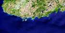
St Lawrence Satellite Image Map
Download Free Aerial Photo 001L14 at 1:50,000 scale
St Lawrence Satellite Imagery
To view this satellite map, mouse over the air photo on the right.
You can also download this satellite image map for free:
001L14 St Lawrence high-resolution satellite image map.
Maps for the St Lawrence aerial map sheet 001L14 at 1:50,000 scale are also available in these versions:
St Lawrence Surrounding Area Aerial Photo Maps
 |
 |
 |
|
© Department of Natural Resources Canada. All rights reserved.
St Lawrence Gazetteer
The following places can be found on satellite image map 001L14 St Lawrence:
St Lawrence Satellite Image: Bays
Back CoveBlue Beach Cove
Castle Hide Cove
Chambers Cove
Corbin Harbour
Deadmans Cove
Deep Cove
Dieters Cove
Dietor Cove
East Bass Cove
Georges Cove
Great St. Lawrence Harbour
Handiland Cove
Hay Cove
Herring Cove
Herring Cove
Herring Cove
L'Anse au Diable
L'Anse au Loup
Little Lawn Harbour
Little St. Lawrence Harbour
Middle Bight Cove
Mine Cove
Murphys Cove
Placentia Bay
Pork Cove
Red Land Cove
Salt Cove
Seal Gulch
Shoal Cove
Silver Cove
Spearns Cove
Speerin Cove
Spices Cove
Swolho Cove
Teddy Bear Cove
Watering Cove
West Bass Cove
St Lawrence Satellite Image: Beaches
Truxtun-Pollux ShoreSt Lawrence Satellite Image: Capes
Bass PointBlue Beach Point
Cape Chapeau Rouge
Cape Rosey
Chambers Point
Corbin Head
Ferryland Head
Flat Point
Keenan Point
L'Anse au Loup Head
Lawn Head
Lawn Point
Little Lawn Point
Long Point
Manasco Head
Middle Head
Middle Head
Miller Head
Red Head
Red Head
Red Head
Sauker Head
Sculpin Point
Shalloway Head
Shingle Point
Spearns Head
Speerin Point
Wester Cove Bass Point
Western Point
St Lawrence Satellite Image: Cliffs
Red CliffSt Lawrence Satellite Image: Forests
Island Pond WoodsTare Fair Woods
St Lawrence Satellite Image: Islands
Cat IslandCorbin Island
Goat Island
Hares Ears
Little Burin Island
Middle Bight Island
Sculpin Island
Shalloway Island
Turpins Island
St Lawrence Satellite Image: Lakes
Bass Cove PondsBeaver Pond
Birchy Gulch Pond
Black Brook Pond
Black Duck Pond
Blakes Pond
Blow Me Down Pond
Boxanator Pond
Brewers Pond
Bryant Pond
Burin Pond
Burnt Woods Pond
Camp Pond
Clam Pond
Clam Pond
Clarkes Pond
Corbin Barasway
Country String of Ponds
Doctors Pond
Eastern Clam Pond
Georges Cove Pond
Grebes Nest Pond
Grebes Nest Pond
Gull Pond
Halfway Pond
Hanamoores Pond
Hares Ears Pond
Hay Pook Pond
Island Pond
Island Pond
John Fitzpatricks Pond
Jones Pond
Juniper Brook Ponds
Knots on Juniper Pond
Lanes Pond
L'Anse au Loup Pond
Little Goose Pond
Little Lawn Pond
Little Stump Pond
Long Pond
Long Pond
Loo Pond
Loughlins Pond
Lucy Anne Pond
Lundrigans Pond
Mount Anne Pond
Mount Misery Ponds
Olands Pond
Orrels Pond
Pepper Pond
Puzzle Ponds
Reeves Pond
Rushy Pond
Salmonier Pond
Sauker Cove Pond
Sharks Pond
Shatter Cliff Pond
Shoal Pond
Silver Cove Ponds
Simmons Hole
Snooks Pond
Southern Pond
Stump Pond
Tent Pond
Three Stick Pond
Tinder Box Bottom Pond
Waterfall Pond
Welchs Pond
Western Clam Pond
Winter Pond
St Lawrence Satellite Image: Mountains
Big HillBlow Me Down Hill
Burnt Woods Hill
Calipouse
Chapeau Rouge
Coopers Ridge
Flint and Steel
Lawn Lookout
Loughlins Hill
Mount Leisure
Mount Lucy Anne
Mount St. Anne
Mount St. Margaret
Pikes Hill
Pinnacle
Ryans Hill
Southwest Hill
St. Anne Mount
St. Margaret Mount
Tinder Box
Turpins Hill
Welchs Hill
White Hills
St Lawrence Satellite Image: Rivers
Black BrookLawn River
Little Lawn River
Little St. Lawrence River
Northeast Brook
Northeast Brook
Orange Springs
Pinnacle Brook
St. Lawrence River
Waterfall Brook
St Lawrence Satellite Image: Shoals
Allen BankBass Rock
Bugdens Rock
Burin Bank
Butler Rock
Cloué Rock
Cockle Rock
Cooper Bank
Douglas's Shoal
Emberly Rock
Fish Rock
Garden Bank
Harbour Rock
Irish Ledge
Kelper Rock
Menaska Shoal
Miller Rock
Monasco Shoal
Offer Rock
Old Harry
Point Rock
Popes Rock
Red Scrape Rock
Rocks of Gibraltar
Rosey Rock
Sauker Rock
Sculpin Rock
Shag Rock
White Ground
White Scrape Rock
St Lawrence Satellite Image: Towns
St. LawrenceSt Lawrence Satellite Image: Unincorporated areas
CorbinLittle St. Lawrence
St Lawrence Satellite Image: Valleys
Tinder Box Bottom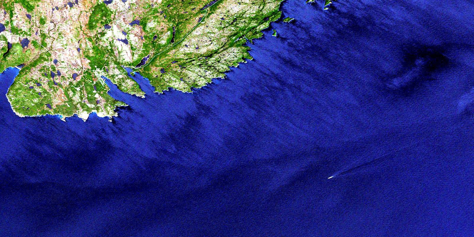
© Department of Natural Resources Canada. All rights reserved.
