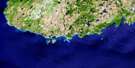
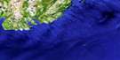
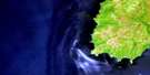
Lamaline Satellite Image Map
Download Free Aerial Photo 001L13 at 1:50,000 scale
Lamaline Satellite Imagery
To view this satellite map, mouse over the air photo on the right.
You can also download this satellite image map for free:
001L13 Lamaline high-resolution satellite image map.
Maps for the Lamaline aerial map sheet 001L13 at 1:50,000 scale are also available in these versions:
Lamaline Surrounding Area Aerial Photo Maps
 |
 |
 |
|
© Department of Natural Resources Canada. All rights reserved.
Lamaline Gazetteer
The following places can be found on satellite image map 001L13 Lamaline:
Lamaline Satellite Image: Bays
Alder GulchBack Cove
Big Gut
Calmer Cove
Cow Cove
Dantzic Cove
Deep Cove
Duck Cove
Eastern Cove
Flagstaff Cove
Fortune Bay
Great Dantzic Cove
Great Lawn Harbour
Hardings Cove
High Beach Cove
Jigging Cove
Jimmys Cove
Joes Cove
Lamaline Bay
Lamaline Harbour
Lamaline Road
Lance Cove
Lannon Cove
Lansey Bank Cove
Lansey Bark Cove
Lawn Bay
Little Dantzic Cove
Little Gut
Little Lawn Harbour
Lord's Cove
Lories Cove
Micks Cove
Muddy Hole
Nantes Cove
Old House Cove
Peters Harbour
Pieduck Cove
Piercey Cove
Point au Gaul Back Cove
Point au Gaul Cove
Point Crewe Cove
Pump Cove
Rack Gulch
Round Cove
Saints Cove
Salmonier Bight
SandyCove
Split Cove
Stabling Cove
Taylor's Bay
The Barasway
Three Sticks Cove
Tiller Cove
Watering Cove
Webbers Cove
West Sandy Cove
Western Cove
Wreck Cove
Lamaline Satellite Image: Beaches
The BarLamaline Satellite Image: Capes
Berry HeadBig Meadow Point
Black Head
Blow Hole Point
Blow Me Down Point
Bluff Head
Burin Peninsula
Cains Point
Calmer Point
Cousin Head
Crew Point
Crows Head
Dantzic Point
Drunkards Point
Duck Point
East Head
East Lories Point
Eastern Point
Flagstaff Point
Fox Hummock
Fox Hummock
Granny Head
Grave Point
Joes Hummock
Land Hummock
Land Point
Lannon Point
Long Point
Penny Point
Pieduck Point
Piercey Point
Pikes Ladder
Pilot Point
Point au Gaul
Point Crewe
Point May
Pump Cove Head
Ragged Head
Red Head
Sand Cove Head
Sandy Cove Point
Sheep Head
Squid Point
Taylor's Bay Point
Three Hummocks
West Woody Hummock
Western Head
Winging Point
Winging Point
Lamaline Satellite Image: Cliffs
Black BankLamaline Satellite Image: Forests
Blue WoodsGreeks Nest
Long Black Wood
Lamaline Satellite Image: Islands
Allan's IslandBarred Island
Big Island
Cat Island
Colombier Islands
Duck Island
Lawn Islands
Little Green Island
Middle Island
Morgan's Island
Offer Island
Pigeon Island
Salmonier Island
Swale Island
Lamaline Satellite Image: Lakes
American PondBakeapple Pond
Bar Pond
Bartle Steaks
Bear Pond
Beaver Pond
Big Dantzic Pond
Big Duck Pond
Big Fox Hummock Pond
Big Meadow Pond
Big Pond
Big Pump Cove Pond
Big Rocky Pond
Big Woody Pond
Black Duck Pond
Black Duck Pond
Black Woods Pond
Brazils Pond
Broad Pond
Browns Pond
Cains Pond
Catchers Pond
Clam Pond
Coxs Pond
Cross Pond
Dantzic Ponds
Deer Pond
Dicks Pond
Dog Hill Pond
Eastern Spell Pond
Fishers Pond
Flagstaff Pond
Flaherty Pond
Flahertys Grove Pond
Flahertys Pond
Fortune Brook Pond
Frenchmans Pond
Garden Pond
Ghost Cop Pond
Glenn Pond
Grassy Pond
Green Hill Pond
Gull Pond
Gull Ponds
Haleys Pond
Hanns Pond
Hare Hill Pond
High Bank Pond
High Beach Pond
Horse Pond
Hungry Pond
Jack Slaneys Pond
Jacky Rat Pond
Jims Pond
Joes Pond
Juniper Pond
Kelp Pond
Kennedys Pond
L Pond
L Pond(shape)
Lanes Pond
Lansey Bark Island Pond
Lansey Bark Pond
Lily Pond
Lily Pond
Little Dantzic Ponds
Little Duck Pond
Little Fox Hummock Pond
Little Horse Pond
Little Pond
Little Rocky Pond
Long Pond
Long Pond
Long Pond
Loo Pond
Loo Pond
Lories Long Pond
Lories Three Ponds
Lousy Pond
Lower Pond
Mans Rock Pond
Middle Pond
Middle Pond
Middle Ridge Pond
Monday Pond
Mount Pleasent Pond
Nantes Cove Pond
Nebway Pond
Northeast Pond
Northwest Pond
Northwest Pond
Northwest Pond
Nut Droke Pond
Otter Pond
Otter Pond
Otter Pond
Paddys Pond
Peters Pond
Piercey Pond
Point May Pond
Poor Pond
Ramrod Pond
Robs Pond
Rocky Pond
Rocky Pond
Rocky Pond
Rocky Pond
Rocky Pond
Round Pond
Salmonier Pond
Sandy Cove Island Pond
Sandy Cove Pond
Shellbird Pond
Shellbird Pond
Shorts Pond
Snooks Barasway
Snooks Pond
Sophies Pond
Spruce Pond
Spruce Pond
Swimming Pond
Taylors Bay Pond
Three Corner Pond
Toe Pond
Tommys Pond
Tommys Pond
Uncle Franks Pond
Warm Water Pond
Watering Pond
Western Pond
Western Spell Pond
Winter Pond
Woody Island Pond
Lamaline Satellite Image: Mountains
Aldery RidgeBen Hill
Berry Hills
Black Hill
Black Woods Hill
Blow Me Down Hill
Brown Hill
Browns Ridge
Cooks Lookout
Dantzic Hill
Eastern Hare Hills
Eastern Ridge
Flagstaff
Flaherty Hill
Fugle Hill
Halfway Hills
Hodges Hill
Kennedy Hill
Lebeach Hill
LeBeach Hill
Lee Beach Hill
Little Burnt Ridge
Lookout
Lookout
Middle Ridge
Middle Ridge
Middle Ridge
Northeast Hill
Northwest Lookout
Penny Hill
Pennys Hill
Piercey Hill
Point au Gaul Hill
Point Crewe Hill
Powderhorn Hill
Rocky Hill
Round Hill
Salmonier Hill
Salmonier Lookout
Sandy Cove Ridge
Split Cove Hill
Tapley Hill
The Breadbox
The Pinnacle
Three Stick Ridge
Western Hare Hills
White Head
Lamaline Satellite Image: Conservation areas
French Islands Provincial ParkLamaline Satellite Image: Rivers
Big Dantzic BrookBobs Brook
Eastern Brook
Hamilton Brook
High Beach Brook
Lories Brook
Middle Brook
Northeast Brook
Northeast Brook
Northwest Brook
Northwest Brook
Peters Brook
Piercey Brook
Salmonier River
Sawpit Dam
Shorts Brook
Snooks Brook
Lamaline Satellite Image: Shoals
Abbott RockAllan Rock
Bateau Bank
Big Rock
Big Salmonier Rock
Blow Hole Rock
Bluff Head Shoal
Bob Rock
Bowdridge Shoal
Breadbox Rock
Caplin Rock
Cock Bank
Collier Rock
East Black Rock
East Mark Rock
East Sunker
Faro Rock
Fish Rock
Frank Rock
Frieght Rock
Harbour Rock
Hillier Rock
Inner Bob Rock
John Thomas Rock
John Walsh Shoal
Johnnie Rocks
Kettle Rocks
Lamaline Ledges
Lamaline Shag Rock
Lawn Bank
Little Salmonier Rock
Little Whalesback Rock
Major Shoal
Middle Ground
Middle Shoal
Murphy Rock
Northwest Sunker
Northwest Sunker
Offer Johnnie Rock
Offer Rock
Otter Rock
Page Rock
Point Rock
Ragged Rock
Ragged Rock
Rogers Rocks
Saint Rock
Sally Rock
Shag Rock
Shag Rock
Shag Rock Shoal
Southeast Rock
Southeast Sunker
Southwest Rock
Strand Rock
Sugarloaf Rock
Taylor's Bay Rock
Taylor's Bay Shoal
The Whalesback
Thornhill Shoal
Thousand Rocks
Tickleace Rock
Vestal Rock
West Black Rock
West Mark Rock
Western Ground
Western Rock
Lamaline Satellite Image: Towns
LamalineLawn
Lord's Cove
Point au Gaul
Point May
Lamaline Satellite Image: Unincorporated areas
Allan's IslandCalmer
High Beach
Lories
Point aux Gaul
Point Crewe
Point May
Roundabout
Taylor's Bay
Webbers
Lamaline Satellite Image: Low vegetation
Old Hill Marsh
© Department of Natural Resources Canada. All rights reserved.
