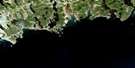
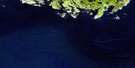
Musquodoboit Harbour Satellite Image Map
Download Free Aerial Photo 011D14 at 1:50,000 scale
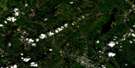
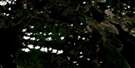
Musquodoboit Harbour Satellite Imagery
To view this satellite map, mouse over the air photo on the right.
You can also download this satellite image map for free:
011D14 Musquodoboit Harbour high-resolution satellite image map.
Maps for the Musquodoboit Harbour aerial map sheet 011D14 at 1:50,000 scale are also available in these versions:
Musquodoboit Harbour Surrounding Area Aerial Photo Maps
 |
 |
 |
 |
 |
 |
 |
|
 |
|||
© Department of Natural Resources Canada. All rights reserved.
Musquodoboit Harbour Gazetteer
The following places can be found on satellite image map 011D14 Musquodoboit Harbour:
Musquodoboit Harbour Satellite Image: Bays
Bear CoveEastern Arm
Grassy Cove
Head of Jeddore
Innis Cove
Jeddore Harbour
Jocks Cove
Mill Cove
Moose Cove
Musquodoboit Harbour
Navy Pool
Northwest Cove
Olivers Cove
Petpeswick Harbour
Petpeswick Inlet
Power Cove
Salmon Inlet
Sandy Cove
Western Arm
Musquodoboit Harbour Satellite Image: Capes
Cordwood Piles PointDuck Head
English Point
Indian Point
Oyster Point
Shortens Point
Musquodoboit Harbour Satellite Image: Channels
Buttermilk ChannelMusquodoboit Harbour Satellite Image: Cliffs
Devils BedMusquodoboit Harbour Satellite Image: Falls
Blue FallsJam Falls
Little River Falls
Musquodoboit Harbour Satellite Image: Geographical areas
HalifaxHants
Musquodoboit Harbour Satellite Image: Islands
Anderson IslandsBig Island
Brown Islands
Byron Island
Chapel Island
Cliffs Island
Deadman Island
Ember Island
Firebrand Island
Grand Island
Hen Island
Mackerel Islands
Mouse Island
Pea Island
Prior Island
Rocky Islands
Shields Head
Spark Island
Musquodoboit Harbour Satellite Image: Lakes
Admiral LakeAsh Hill Lake
Ash Hill Lake
Back Duck Lake
Bakers Lake
Barren Lake
Bayer Lake
Bear Cove Lake
Bear Lake
Bear Lake
Beaver Lake
Beaver Lake
Beaver Pond
Beckwith Lake
Beckwood Lake
Bell Lake
Bell Lake
Bell Lake
Bens Lake
Big Duck Lake
Big Lake
Big Pilgrim Lake
Big Tom Lake
Billys Pond
Birch Lake
Blair Lake
Bottle Lake
Bridge End Lake
Brooks Lakes
Brown Pond
Browns Lake
Browns Pond
Bruce Lake
Buckley Lake
Burnt Lake
Byron Lake
Byron Lake
Camp Lake
Camp Lake
Camp Lakes
Campbells Pond
Camphill Lake
Canoe Lake
Caribou Lake
Catamaran Lake
Catamaran Lakes
Centre Lake
Chain Lakes
Chain of Lakes
Chezzetcook Lake
Christopher Lake
Church Lake
Church Lake
Clearwater Lake
Clearwater Lake
Clump Lake
Collins Lake
Commissary Meadow Lake
Conrod Lake
Cope Lake
Copes Hill Lake
Cousins Lake
Cove Lake
Cranberry Lake
Cranberry Lake
Cranberry Lake
Cranberry Lake
Cranberry Lake
Crawford Lake
Crazy Colls Slough Hole
Crocket Lake
Crooked Lake
Crow Lake
Crowbar Lake
Dam Lake
Dark Lake
Dark Pond
Deadman Lake
Decoy Lake
Dilman Lake
Dollar Lake
Donkin Lake
Dooks Lake
Dooks Pond
Drew Lake
Drews Trout Pond
Drummer Lake
Dry Lake
Duck Lake
Duck Lake
Duck Lake
Duck Lake
Duck Lakes
Duck Pond
Duck Pond
Dudley Lake
Eagle Lake
East Lake
East Lake
East Lake
East Lake
East Lake
Eastern Richardson Pond
Eastern Run Lake
Eel Pond
Elbow Lake
Elbow Pond
Ernst Lake
Eunice Lake
Eureka Lake
Farquhar Lake
Farquhars Lake
Faulkner Lake
Faulkner Lake
Fiddle Lake
Fish Lake
Fishing Lake
Five Island Lake
Flat Iron Lake
Flat Lake
Flat Lakes
Fox Lake
Fuller Lake
Fuller Lake
Gazette Lake
Gibraltar Lake
Gillespie Lake
Goose Lake
Graham Lake
Grand Lake
Granite Lake
Granite Lake
Granite Lake
Grant Lake
Grassy Lake
Grassy Lake
Grassy Lake
Grassy Lake
Grassy Lake
Griswold Lake
Gull Lake
Hackmatack Lake
Hard Scrabble Lake
Hartman Lake
Higgins Lake
Hilltop Lake
Horseshoe Lake
Horseshoe Lake
Howe Lake
Hurley Lake
Island Lake
Jack Weeks Lake
Jeddore Lake
Jim Grant Ponds
John Brayden Lake
Johnson Lake
Julien Pond
Kerr Lake
Knowlan Lake
Lac aux Pattes
Lake Brown
Lake Charlotte
Lake Eagle
Lake Egmont
Lake George
Lake Major
Lake No Good
Lake Williams
Lamprey Lake
Lantz Pond
Lawrence Lake
Lay Lake
Ledwidge Lake
Lewis Lake
Lewis Lake
Lily Pad Lake
Lily Pond
Little Browns Lake
Little Camp Lake
Little Duck Lake
Little Duck Lake
Little Eel Pond
Little Harbour Road Lake
Little Hartman Lake
Little Lake
Little Lake
Little Lake
Little Lake
Little Lake
Little Lake
Little Lake
Little Lake Brown
Little Lake No Good
Little Lily Pond
Little Moose Lake
Little River Lake
Little Rock Lake
Little Rocky Lake
Little Scotch Pond
Little Sixmile Lake
Little Tom Lake
Lively Lake
Logan Lake
Logging Lake
Logging Lake Pond
Long Bridge Lake
Long Duck Lake
Loon Lake
Loon Lake
Loon Lake
Lower Egmont Lake
Maple Hill Lake
Maple Hill Lake
Maskell Pond
McCaffrey Lake
McCaffrey Long Lake
McCullough Lake
McKay Lake
McKay Pond
McMullin Lake
Mill Pond
Milne Lake
Milnes Lake
Mitchell Lake
Mitchells Hill South Lake
Mitchells Hill West Lake
Mitt Lake
Moore Lake
Moose Cove Lake
Moose Cove Lakes
Moose Lake
Moose Lake
Moose Lake
Moose Pond
Mountain Lake
Mud Hole
Mud Lake
Mud Pond
Murphy Lake
Murphys Lake
Mystery Lake
Narrow Lake
New Found Lake
No Good Lake
North Lake
North Lakes
North West Lake
Oak Lake
O'Brien Lake
Officers Camp Lake
Old Harbour Road Lake
Otter Lake
Otter Lake
Otter Lake
Otter Lake
Otter Pond
Oyster Pond
Oyster Pond
Pace Lake
Paces Lake
Paint Lake
Pea Island Lake
Petpeswick Lake
Pilgrim Lakes
Pine Grove Lake
Pine Lake
Pine Lake
Pine Lake
Piney Lake
Poplar Lake
Porcupine Lake
Porcupine Lake
Porcupine Pond
Portapique Lake
Porter Lake
Porters Lake
Pot Lake
Pot Lake
Preston Long Lake
Quaver Lake
Rabbits Lake
Red Lake
Red Lake
Reid Lake
Richardson Lake
Richardson Pond
River Lake
Robert Lake
Roberts Little Lake
Robinson Lake
Robinsons Lake
Rockhead Lake
Rocky Lake
Rocky Lake
Rocky Lake
Rocky Lake
Rocky Lake
Rocky Lake
Rocky Lake
Rocky Lake
Rocky Lake
Rocky Lake
Rocky Lake
Rodgers Duck Lake
Round Lake
Round Lake
Round Pond
Round Pond
Round Pond
Roy Lake
Ruggs Lake
Saddleback Lake
Salmon River Lake
Salmon River Long Lake
Samson Carter Pond
Sandy Lake
Scotch Pond
Scots Lake
Scots Pond
Scott Lake
Scrabble Lake
Shaw Big Lake
Shaw Little Lake
Shea Lake
Sherriff Lake
Ship Harbour Lake
Ship Harbour Long Lake
Skull Lake
Skull Lake Pond
Sole Lake
Soles Lake
Solomons Pond
South Red Trout Lake
Sparks Lake
Sparrow Lake
Spider Lake
Spoon Lake
Square Lake
Squints Lake
Stillwater Lake
Sucker Lake
Sugar Camp Lake
Thief Lake
Thompson Lake
Three Mile Lake
Tittle Lake
Tomson Lake
Triplet Lake
Trout Lake
Trout Lake
Trout Lake
Trout Lake
Tully Lake
Turf Lake
Turtle Lake
Turtle Lake
U.M. Lake
Water Lily Lake
Webber Lake
West Lake
West Lake
Western Richardson Pond
White Horse Lake
White Lake
Wildcat Lake
Wisdom Mill Lake
Woody Lake
Y Lake
Yellow Lily Lake
Musquodoboit Harbour Satellite Image: Mountains
Bear HillBlue Hill
Farquhars Mountain
Gibraltar Hill
Gibraltar Rock
Jerusalem Hill
Johnson Hill
Lookout Hill
Mount Tom
Nuttall Hill
Reid Hill
Soles Hill
Musquodoboit Harbour Satellite Image: Major municipal/district area - major agglomerations
East HantsHalifax
Musquodoboit Harbour Satellite Image: Conservation areas
Dollar Lake Provincial ParkWaverley Game Sanctuary
Waverley Salmon River Long Lake Wilderness Area
Musquodoboit Harbour Satellite Image: Rivers
Abraham BrookAbrahams Brook
Acadian Brook
Annand Brook
Baker Brook
Bakers Brook
Barney Brook
Barneys Brook
Bear Brook
Bear Meadow Brook
Beaver Brook
Black Brook
Camphill Brook
Caribou Brook
Chezzetcook River
Clattenburgh Brook
Cousins Meadow Brook
Cranberry Lake Brook
Curran Brook
Deadman Island Brook
Dollar Lake Brook
Doyles Brook
Drinking Brook
East Brook
East Brook
East Brook
Eastern Run
Far Brook
Fish Hawk Nest River
Grono Brook
Hardwood Brook
Hartman Brook
Hirtle Brook
Kaulback Brook
Keys Brook
Leech Brook
Little River
Little River
Lively Brook
MacDonald Brook
McDonald Brook
McDowell Brook
McMullin Meadow Brook
Meadow Brook
Meadow Brook
Meadow Brook
Mill Brook
Mill Brook
Mill Brook
Miller Brook
Milne Brook
Milnes Brook
Mosher Brook
Musquodoboit River
Nine Mile River
Ninemile River
North Run
Northeast Brook
Northwest Cove Brook
Nuttall Brook
Ogilvie Brook
Paddys Brook
Pond Brook
Quarry Brook
Robinsons Brook
Rocky Brook
Rodgers Brook
Rogers Brook
Ruggs Brook
Salmon River
Salmon River
Shea Lake Brook
Shubenacadie River
Smelt Brook
Smelt Brook
Softwood Brook
South Branch
South Branch Gays River
South Gay River
Spriggs Brook
Stevens Brook
Stillwater Brook
Stillwater Brook
Stingle Brook
Storey Brook
Sucker Brook
The Gullies
Three Bridges Brook
Trout Brook
West Brook
Musquodoboit Harbour Satellite Image: River features
Alder DeadwaterBig Deadwater
Blue Falls Pool
Bridge Pool
Chain of Lakes Stillwaters
Eastern Run Deadwaters
First Deadwater
Flat Pool
Graveyard Pool
Long Deadwater
Long Stillwater
North Lake Deadwater
Railroad Bridge Pool
Second Deadwater
Silvers Pool
Soles Stillwater
Tom Vaughans Pool
Musquodoboit Harbour Satellite Image: Shoals
Kempts LedgeMusquodoboit Harbour Satellite Image: Unincorporated areas
AntrimBarney Brook
Barneys Brook
Conrod Settlement
Devon
Dutch Settlement
East Petpeswick
Elderbank
Gaetz Brook
Gibraltar
Goff
Goffs
Goff's
Greenough Settlement
Grono Road
Hartlin Settlement
Head of Jeddore
Jeddore Oyster Pond
Lake Egmont
Lantz
Lantz Siding
Lower Meagher Grant
Lower Meaghers Grant
Meagher
Meagher Grant
Meaghers Grant
Murchyville
Musquodoboit Harbour
Myers Point
New Road
North Preston
Oldham
Oyster Pond
Salmon River Bridge
Smith Settlement
Smiths Settlement
West Petpeswick
Wyse Corner
Wyses Corner
Musquodoboit Harbour Satellite Image: Valleys
Musquodoboit ValleyMusquodoboit Harbour Satellite Image: Low vegetation
Bear MeadowBig Plain
Bruce Plain
Caribou Bog
Cope Plain
Curren Bog
Dicks Meadows
Doyle Meadows
Horne Meadows
Innis Meadow
Kaulback Bog
Kaulback Meadow
Kelly Meadow
Lindsay Meadows
McDowell Bog
McMullin Meadows
Millers Meadow
Parks Meadow
Porcupine Meadow
South Meadow

© Department of Natural Resources Canada. All rights reserved.
