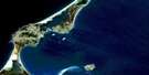
Cape St Lawrence Satellite Image Map
Download Free Aerial Photo 011N02 at 1:50,000 scale
Cape St Lawrence Satellite Imagery
To view this satellite map, mouse over the air photo on the right.
You can also download this satellite image map for free:
011N02 Cape St Lawrence high-resolution satellite image map.
Maps for the Cape St Lawrence aerial map sheet 011N02 at 1:50,000 scale are also available in these versions:
Cape St Lawrence Surrounding Area Aerial Photo Maps
 |
|||
 |
|||
 |
|||
 |
 |
 |
© Department of Natural Resources Canada. All rights reserved.
Cape St Lawrence Gazetteer
The following places can be found on satellite image map 011N02 Cape St Lawrence:
Cape St Lawrence Satellite Image: Bays
Bay St. LawrenceFox Den
Golfe du Saint-Laurent
Gulf of St. Lawrence
Lowland Cove
Meat Cove
Sailor Cove
St. Lawrence Bay
Wreck Cove
Cape St Lawrence Satellite Image: Beaches
Fraser BeachFrasers Beach
Cape St Lawrence Satellite Image: Capes
Black PointBlackrock
Blackrock Point
Cape St. Lawrence
Grassy Point
Little Grassy Point
Lowland Point
Pats Point
Rhu Pillinn
Tittle Point
Cape St Lawrence Satellite Image: Channels
Cabot StraitCabot Strait
Détroit de Cabot
Détroit de Cabot
Cape St Lawrence Satellite Image: Geographical areas
InvernessJuste au Corps
Victoria
Cape St Lawrence Satellite Image: Islands
Cape Breton IslandÎle du Cap-Breton
Cape St Lawrence Satellite Image: Lakes
Big PondCape St Lawrence Satellite Image: Mountains
Bear HillCape St Lawrence Satellite Image: Major municipal/district area - major agglomerations
InvernessVictoria
Cape St Lawrence Satellite Image: Rivers
Black BrookBlack Point Brook
Edwards Brook
French Brook
Jumping Brook
Lowland Brook
Lowland Brook
Meat Cove Brook
Pine Brook
Sailor Brook
Wreck Cove Brook
Cape St Lawrence Satellite Image: Shoals
Black RockShag Rock
Cape St Lawrence Satellite Image: Unincorporated areas
Black PointCapstick
Meat Cove

© Department of Natural Resources Canada. All rights reserved.
