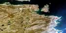
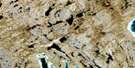
Lac Voltz Satellite Image Map
Download Free Aerial Photo 024N04 at 1:50,000 scale
Lac Voltz Satellite Imagery
To view this satellite map, mouse over the air photo on the right.
You can also download this satellite image map for free:
024N04 Lac Voltz high-resolution satellite image map.
Maps for the Lac Voltz aerial map sheet 024N04 at 1:50,000 scale are also available in these versions:
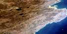
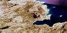
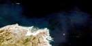
Lac Voltz Surrounding Area Aerial Photo Maps
 |
|||
 |
|||
 |
 |
||
 |
 |
 |
© Department of Natural Resources Canada. All rights reserved.
Lac Voltz Gazetteer
The following places can be found on satellite image map 024N04 Lac Voltz:
Lac Voltz Satellite Image: Bays
Baie IkattokBaie Niurluk
Ikattok Bay
Lac Voltz Satellite Image: Lakes
Lac AmmalurtuuqLac aux Feuilles
Lac Brûlé
Lac Déry
Lac Ford
Lac Hind
Lac Ippialuup
Lac Laliberté
Lac Lambda
Lac Nipirqanaup Kangillinga
Lac Nuluarniavik
Lac Voltz
Lac Voltz Satellite Image: Mountains
Colline QalirusiarjuupColline Qingaujaq
Collines Qingaujaup
Lac Voltz Satellite Image: Rivers
Rivière AarsutaupRivière Boyer
Rivière Buron
Ruisseau Voltz

© Department of Natural Resources Canada. All rights reserved.
