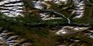
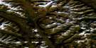
Seaplane Lake Satellite Image Map
Download Free Aerial Photo 095E07 at 1:50,000 scale
Seaplane Lake Satellite Imagery
To view this satellite map, mouse over the air photo on the right.
You can also download this satellite image map for free:
095E07 Seaplane Lake high-resolution satellite image map.
Maps for the Seaplane Lake aerial map sheet 095E07 at 1:50,000 scale are also available in these versions:
Seaplane Lake Surrounding Area Aerial Photo Maps
 |
 |
 |
 |
 |
 |
 |
 |
 |
 |
 |
 |
 |
 |
 |
 |
© Department of Natural Resources Canada. All rights reserved.
Seaplane Lake Gazetteer
The following places can be found on satellite image map 095E07 Seaplane Lake:
Seaplane Lake Satellite Image: Lakes
Loon LakeMcLeod Lake
Mickey Lake
Mineral Lake
Seaplane Lake
Seaplane Lake Satellite Image: Mountains
Logan MountainsSelwyn Mountains
Two Cones Mountain
Seaplane Lake Satellite Image: Conservation areas
Nahanni National Park Reserve of CanadaRéserve de parc national du Canada Nahanni
Seaplane Lake Satellite Image: Plains
Liard PlateauSeaplane Lake Satellite Image: Rapids
Cascade of the Thirteen StepsSeaplane Lake Satellite Image: Rivers
Bennett CreekBorden Creek
Flat River
Grizzly Creek
McLeod Creek
Moose Creek
Seaplane Lake Satellite Image: Springs
Wildmint HotspringsSeaplane Lake Satellite Image: Territory
Northwest TerritoriesTerritoires du Nord-Ouest
Seaplane Lake Satellite Image: Valleys
Flat River Canyon
© Department of Natural Resources Canada. All rights reserved.
095E Related Maps:
095E Flat River095E01 Stonemarten Lakes
095E02 Skinboat Lakes
095E03 No Title
095E04 No Title
095E05 Caesar Lakes
095E06 No Title
095E07 Seaplane Lake
095E08 No Title
095E09 No Title
095E10 Irvine Creek
095E11 Pass Creek
095E12 Bear Pass Creek
095E13 Mount Sidney Dobson
095E14 Hole In The Wall Lake
095E15 Hell Roaring Creek
095E16 Flood Creek
