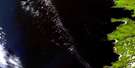
Langara Satellite Image Map
Download Free Aerial Photo 103K03 at 1:50,000 scale
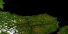
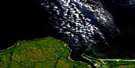
Langara Satellite Imagery
To view this satellite map, mouse over the air photo on the right.
You can also download this satellite image map for free:
103K03 Langara high-resolution satellite image map.
Maps for the Langara aerial map sheet 103K03 at 1:50,000 scale are also available in these versions:
Langara Surrounding Area Aerial Photo Maps
 |
 |
 |
© Department of Natural Resources Canada. All rights reserved.
Langara Gazetteer
The following places can be found on satellite image map 103K03 Langara:
Langara Satellite Image: Bays
Beresford BayCloak Bay
Fury Bay
Hazardous Cove
Henslung Cove
Lepas Bay
Lord Bight
Sialun Bay
Langara Satellite Image: Capes
Cape KnoxCaswell Point
Fleurieu Point
Hart Point
Iphigenia Point
Langara Point
Lauder Point
Meares Point
Rhodes Point
Sadler Point
St. Margaret Point
White Point
Langara Satellite Image: Channels
Boat PassageKusgwai Passage
Parry Passage
Langara Satellite Image: Indian Reserves
Guoyskun Indian Reserve 22Kioosta Indian Reserve 15
Réserve indienne Guoyskun 22
Réserve indienne Kioosta 15
Réserve indienne Yasitkun 21
Yasitkun Indian Reserve 21
Langara Satellite Image: Islands
Cox IslandGraham Island
Lacy Island
Langara Island
Queen Charlotte Islands
Thrumb Islet
Langara Satellite Image: Mountains
Newcombe HillPivot Mountain
Pyramid Hill
Langara Satellite Image: Rivers
Beresford CreekHana Koot Creek
Sialun Creek
Langara Satellite Image: Shoals
Astrolabe RockCarew Rock
Chanal Reef
Gatenby Rock
Harvey Rock
La Pérouse Reef
Langara Rocks
Marchand Reef
Ocean Shoal
Sunday Reef
Swanton Bank
Turner Reef
Langara Satellite Image: Unincorporated areas
KiustaYaku

© Department of Natural Resources Canada. All rights reserved.
