Lac Amaruartuq Topo Map Online
Download Free Topo Map Sheet 024I14 at 1:50,000 scale
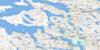
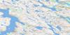
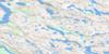
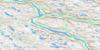
024I14 Lac Amaruartuq Topo Map
To view this map, mouse over the map preview on the right.
You can also download this topo map for free:
024I14 Lac Amaruartuq high-resolution topo map image.
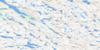
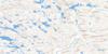
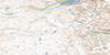
Maps for the Lac Amaruartuq topo map sheet 024I14 at 1:50,000 scale are also available in these versions:
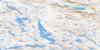
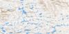
Lac Amaruartuq Surrounding Area Topo Maps
 |
 |
 |
 |
 |
 |
 |
 |
 |
 |
 |
 |
 |
 |
 |
 |
© Department of Natural Resources Canada. All rights reserved.
Lac Amaruartuq Gazetteer
The following places can be found on topographic map sheet 024I14 Lac Amaruartuq:
Lac Amaruartuq Topo Map: Bays
Baie TasikallakLac Amaruartuq Topo Map: Lakes
Lac AmaruartuqLac Angusik
Lac Amaruartuq Topo Map: Mountains
Colline IllaigutaujaqLac Amaruartuq Topo Map: Rivers
Rivière BaudanRivière Baudoncourt

© Department of Natural Resources Canada. All rights reserved.
024I Related Maps:
024I Riviere Koroc024I01 Lac Biraben
024I02 Lac Tasirlaq
024I03 Lac Ijurvik
024I04 Rapides Sarvakallak
024I05 Lac Kupaaluk
024I06 Mt Nuvulialuk
024I07 Lac Brumath
024I08 Lac Tasiguluk
024I09 Mont Haywood
024I10 Chute Korluktok
024I11 Ruisseau Naksaluk
024I12 Kangiqsualujjuaq
024I13 Lac Qarliik
024I14 Lac Amaruartuq
024I15 Lac Thoynard
024I16 Mount Silene
