Livingston Lake Topo Map Online
Download Free Topo Map Sheet 064B07 at 1:50,000 scale
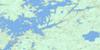
064B07 Livingston Lake Topo Map
To view this map, mouse over the map preview on the right.
You can also download this topo map for free:
064B07 Livingston Lake high-resolution topo map image.
Maps for the Livingston Lake topo map sheet 064B07 at 1:50,000 scale are also available in these versions:
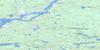
Livingston Lake Surrounding Area Topo Maps
 |
 |
 |
 |
 |
 |
 |
 |
 |
 |
 |
 |
 |
 |
 |
 |
© Department of Natural Resources Canada. All rights reserved.
Livingston Lake Gazetteer
The following places can be found on topographic map sheet 064B07 Livingston Lake:
Livingston Lake Topo Map: Capes
English PeninsulaLivingston Lake Topo Map: Channels
White NarrowsLivingston Lake Topo Map: Islands
Hodgson IslandLivingston Lake Topo Map: Lakes
Anderson LakeKakeenokamasik Lake
Kinwaw Lake
Livingston Lake
Misseepastikwayakos Lake
Ridge Lake
Walesiak Lake
Wapayko Lake
Wasioskatukaw Lake
Livingston Lake Topo Map: Rivers
Ochuleepis RiverRat River
Taylor Creek

© Department of Natural Resources Canada. All rights reserved.
064B Related Maps:
064B Uhlman Lake064B01 Harding Lake
064B02 Leftrook Lake
064B03 Mynarski Lakes
064B04 Goodwin Lake
064B05 Pemichigamau Lake
064B06 Earp Lake
064B07 Livingston Lake
064B08 Barnes Lake
064B09 Broughton Lake
064B10 Swan Bay
064B11 Issett Lake
064B12 Opachuanau Lake
064B13 Fraser Lake
064B14 Lemay Island
064B15 Cousins Lake
064B16 Chapman Lake
