Little Sand Lake Topo Map Online
Download Free Topo Map Sheet 064G15 at 1:50,000 scale
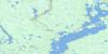
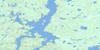
064G15 Little Sand Lake Topo Map
To view this map, mouse over the map preview on the right.
You can also download this topo map for free:
064G15 Little Sand Lake high-resolution topo map image.
Maps for the Little Sand Lake topo map sheet 064G15 at 1:50,000 scale are also available in these versions:
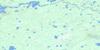
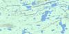
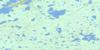
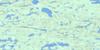
Little Sand Lake Surrounding Area Topo Maps
 |
 |
 |
 |
 |
 |
 |
 |
 |
 |
 |
 |
 |
 |
 |
 |
© Department of Natural Resources Canada. All rights reserved.
Little Sand Lake Gazetteer
The following places can be found on topographic map sheet 064G15 Little Sand Lake:
Little Sand Lake Topo Map: Bays
Maxwell BayMorris Bay
Snead Bay
Little Sand Lake Topo Map: Capes
Little PointLittle Sand Lake Topo Map: Islands
Woods IslandLittle Sand Lake Topo Map: Lakes
Chipewyan LakeCommemoration Lake
Cosens Lake
Earl Lake
Gibb Lake
Hollis Lake
John McKay Lake
Leroux Lake
Little Sand Lake
Loon Lake
Millon Lake
Mokanyk Lake
Muhekun Lake
Otter Lake
Sandberg Lake
Smyth Lake
Snead Lake
Sydney Smith Lake
Trout Lake
Walld Lake
Little Sand Lake Topo Map: Mountains
Campbell EskerLittle Sand Lake Topo Map: Conservation areas
Sand Lakes Provincial ParkLittle Sand Lake Topo Map: Rivers
Boyd CreekLittle Sand River
South Seal River
Trout Creek
Umisko River
Little Sand Lake Topo Map: Road features
Keskamutinawok Portage
© Department of Natural Resources Canada. All rights reserved.
064G Related Maps:
064G Big Sand Lake064G01 Torrance Lake
064G02 Numakoos Lake
064G03 Mulcahy Lake
064G04 Grandmother Lake
064G05 James Lake
064G06 Mackerracher Lake
064G07 Nutter Lake
064G08 Missi Rapid
064G09 Hammond Point
064G10 Moss Lake
064G11 Sedgwick Lake
064G12 Hendry Lake
064G13 Maxwell Lake
064G14 Wolf Lake
064G15 Little Sand Lake
064G16 Chipewyan Lake
