Pink Mountain Topo Map Online
Download Free Topo Map Sheet 094G02 at 1:50,000 scale
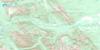
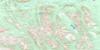
094G02 Pink Mountain Topo Map
To view this map, mouse over the map preview on the right.
You can also download this topo map for free:
094G02 Pink Mountain high-resolution topo map image.
Maps for the Pink Mountain topo map sheet 094G02 at 1:50,000 scale are also available in these versions:
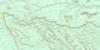
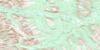
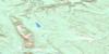
Pink Mountain Surrounding Area Topo Maps
 |
 |
||
 |
 |
 |
|
 |
 |
 |
 |
 |
 |
 |
 |
© Department of Natural Resources Canada. All rights reserved.
Pink Mountain Gazetteer
The following places can be found on topographic map sheet 094G02 Pink Mountain:
Pink Mountain Topo Map: Lakes
Lifeline LakeLily Lake
Pink Mountain Topo Map: Mountains
Pink MountainRocky Mountain Foothills
Pink Mountain Topo Map: Major municipal/district area - major agglomerations
Peace River Regional DistrictPink Mountain Topo Map: Conservation areas
Pink Mountain ParkPink Mountain Topo Map: Plains
Peace River LowlandPink Mountain Topo Map: Rivers
Atick CreekBarker Creek
Beatton River
Cameron River
Elbow Creek
Halfway River
Mason Creek
Moose Lick Creek
Quarter Creek
Sikanni Chief River
Two Bit Creek
Wapistan Creek
Pink Mountain Topo Map: River features
The ElbowPink Mountain Topo Map: Unincorporated areas
Beatton RiverPink Mountain
Sikanni Chief

© Department of Natural Resources Canada. All rights reserved.
094G Related Maps:
094G Trutch094G01 Julienne Creek
094G02 Pink Mountain
094G03 Marion Lake
094G04E Mount Mccusker
094G04W Mount Mccusker
094G05E Redfern Lake
094G05W Redfern Lake
094G06E Mount Withrow
094G06W Mount Withrow
094G07 Caribou Creek
094G08 Medana Creek
094G09 Donnie Creek
094G10 Trutch
094G11E Minaker River
094G11W Minaker River
094G12E Richards Creek
094G12W Richards Creek
094G13 Kluachesi Lake
094G14E Bunch Creek
094G14W Bunch Creek
094G15 Bougie Creek
094G16 Boat Creek
