Brooke Creek Topo Map Online
Download Free Topo Map Sheet 115F10 at 1:50,000 scale
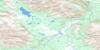
115F10 Brooke Creek Topo Map
To view this map, mouse over the map preview on the right.
You can also download this topo map for free:
115F10 Brooke Creek high-resolution topo map image.
Maps for the Brooke Creek topo map sheet 115F10 at 1:50,000 scale are also available in these versions:
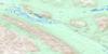
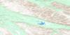
Brooke Creek Surrounding Area Topo Maps
 |
 |
||
 |
 |
||
 |
 |
||
 |
 |
© Department of Natural Resources Canada. All rights reserved.
Brooke Creek Gazetteer
The following places can be found on topographic map sheet 115F10 Brooke Creek:
Brooke Creek Topo Map: Glaciers
Brooke GlacierKlutlan Glacier
Natazhat Glacier
Brooke Creek Topo Map: Mountains
Kletsan HillKluane Ranges
Mount Lambart
Slaggard Ridge
Solomon Ridge
St. Elias Mountains
Brooke Creek Topo Map: Rivers
Big Boundary CreekBrooke Creek
Cache Creek
Count Creek
Edith Creek
Generc River
Harris Creek
Kletsan Creek
Klutlan River
Koidern River
Little Boundary Creek
Soda Creek
St. Clare Creek
White River

© Department of Natural Resources Canada. All rights reserved.
