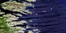
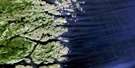
Comfort Bight Satellite Image Map
Download Free Aerial Photo 003E04 at 1:50,000 scale
Comfort Bight Satellite Imagery
To view this satellite map, mouse over the air photo on the right.
You can also download this satellite image map for free:
003E04 Comfort Bight high-resolution satellite image map.
Maps for the Comfort Bight aerial map sheet 003E04 at 1:50,000 scale are also available in these versions:
Comfort Bight Surrounding Area Aerial Photo Maps
 |
|||
 |
|||
 |
© Department of Natural Resources Canada. All rights reserved.
Comfort Bight Gazetteer
The following places can be found on satellite image map 003E04 Comfort Bight:
Comfort Bight Satellite Image: Bays
American CoveCaplin Bay
Comfort Bight
Duck Cove
Eagle Cove
Frenchmans Harbour
George Harbour
Hawke Bay
Hawke Harbour
Hill Harbour
Hills Harbour
Holloway Bight
Partridge Bay
Penguin Harbour
Penny Harbour
Punchbowl
Rocky Bay
Salt Pond
Scrape Cove
Shoal Bay
Sloop Harbour
Styles Harbour
The Harbour
Wild Bight
Comfort Bight Satellite Image: Capes
Cox HeadFish Point
Owl Head
Partridge Head
Comfort Bight Satellite Image: Channels
American TickleFrenchmans Run
Squasho Run
Comfort Bight Satellite Image: Islands
American IslandBear Island
Bear Islands
Big Island
Copper Island
Cox Island
Crow Island
Deepwater Island
Deepwater Island
Dog Island
Duck Islands
Entry Island
Fish Island
Flat Island
Flat Island
Fling Islands
Fox Islands
Frenchmans Island
Greens Island
Gulnare Island
Hare Island
Harper Island
Haven Islet
Hawke Island
Hiscock Islands
Kennedy Island
Ledge Island
Long Island
Old Jeff Island
Pig Island
Pigeon Island
Red Island
Red Island
Red Island
Seal Island
Seine Island
Sleepy Island
South Gulnare Island
South Three Islands
Sparrowbill Island
Stag Island
Stony Island
The Brandies
The Ravens
The Sugar Loaf
Transport Island
Comfort Bight Satellite Image: Mountains
SugarloafComfort Bight Satellite Image: Seas
Labrador SeaMer du Labrador
Comfort Bight Satellite Image: Shoals
Ambush RockBlack Rock
Black Rock
Bobby Rocks
Boulter Rock
Connors Rocks
Crow Island Rocks
Dawley Bank
Dorothy Square
Flat Island Rock
Flat Rocks
Locks Rock
Louse Rock
Mad Moll
No-mans-land
Old King
Pollo Rock
South Bantam
The Cobbler
The Feather Bed
The Hump
The Pippies
The Planter
The Squire
Turr Rocks
Comfort Bight Satellite Image: Unincorporated areas
Comfort BightFrenchmans Island
Hawke Harbour
Seal Islands Harbour

© Department of Natural Resources Canada. All rights reserved.
