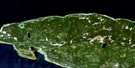
Petit-Cap Satellite Image Map
Download Free Aerial Photo 022H01 at 1:50,000 scale
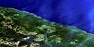
Petit-Cap Satellite Imagery
To view this satellite map, mouse over the air photo on the right.
You can also download this satellite image map for free:
022H01 Petit-Cap high-resolution satellite image map.
Maps for the Petit-Cap aerial map sheet 022H01 at 1:50,000 scale are also available in these versions:
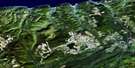
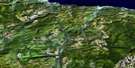
Petit-Cap Surrounding Area Aerial Photo Maps
 |
|||
 |
|||
 |
 |
 |
 |
© Department of Natural Resources Canada. All rights reserved.
Petit-Cap Gazetteer
The following places can be found on satellite image map 022H01 Petit-Cap:
Petit-Cap Satellite Image: Bays
Anse à BélandAnse du Petit Cap
Gulf of St. Lawrence
La Grande Anse
Petit-Cap Satellite Image: Capes
Cap aux GoélandsCap Barré
Cap Barré
Cap du Sud-Ouest
Cap Goillon
Cap Nord-Est
Le Petit Cap
Pointe de l'Échouerie
Pointe du Nord-Ouest
Pointe du Serpent
Pointe Samuel
Petit-Cap Satellite Image: Channels
Détroit d'HonguedoPassage Gaspé
Petit-Cap Satellite Image: City
GaspéPetit-Cap Satellite Image: Geographical areas
FoxPetit-Cap Satellite Image: Lakes
Deuxième LacLac Castor
Lac de l'Épinette Rouge
Lac du Moulin
Lac du Petit Rocher
Premier Lac
Troisième Lac
Petit-Cap Satellite Image: Mountains
Monts Chic-ChocsMonts Shickshock
Petit-Cap Satellite Image: Conservation areas
Forillon National Park of CanadaParc de Forillon
Parc national de Forillon
Petit-Cap Satellite Image: Rivers
Petite rivière au RenardRuisseau à Chouinard
Ruisseau Dunn
Ruisseau Jalbert
Ruisseau Marble
Petit-Cap Satellite Image: Road features
Pont MorrisPetit-Cap Satellite Image: Shoals
Récif du SerpentPetit-Cap Satellite Image: Unincorporated areas
L'ÉchouerieL'Échouerie
Petit-Cap
Petit-Cap
Petite-Rivière-au-Renard
Rivière-au-Renard-Ouest
Saint-Maurice-de-l'Échouerie
Petit-Cap Satellite Image: Valleys
Coulée à Octave-GirardCoulée des Jalbert
Coulée des Lots
Petit-Cap Satellite Image: Villages
Anse-aux-GriffonsBaie-de-Gaspé-Nord
Baie-de-Gaspé-Sud
Douglas
Grande-Grève
Haldimand
L'Anse-au-Griffon
Rivière-au-Renard
Saint-Alban-du-Cap-des-Rosiers
Saint-Majorique
Saint-Maurice
Sydenham-Sud
York
© Department of Natural Resources Canada. All rights reserved.
