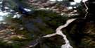
Tempest Mountain Satellite Image Map
Download Free Aerial Photo 115F08 at 1:50,000 scale
Tempest Mountain Satellite Imagery
To view this satellite map, mouse over the air photo on the right.
You can also download this satellite image map for free:
115F08 Tempest Mountain high-resolution satellite image map.
Maps for the Tempest Mountain aerial map sheet 115F08 at 1:50,000 scale are also available in these versions:
Tempest Mountain Surrounding Area Aerial Photo Maps
 |
 |
||
 |
 |
||
 |
 |
||
 |
 |
© Department of Natural Resources Canada. All rights reserved.
Tempest Mountain Gazetteer
The following places can be found on satellite image map 115F08 Tempest Mountain:
Tempest Mountain Satellite Image: Glaciers
Gibson GlacierHazard Glacier
Moffat Glacier
Mount Wood Glacier
Steele Glacier
Tempest Mountain Satellite Image: Mountains
Icefield RangesMount Byron
Mount McBride
Panorama Ridge
Promenade Mountain
St. Elias Mountains
Teapot Mountain
Tempest Mountain
Terrace Mountain
Tempest Mountain Satellite Image: Conservation areas
Kluane National Park and Reserve of CanadaKluane/Wrangell-St. Elias/Glacier Bay/Tatshenshini-Alsek World Heritage Site
Parc national et réserve de parc national du Canada Kluane
Site du patrimoine mondial Kluane/Wrangell-St. Elias/Glacier Bay/Tatshenshini-Alsek
Tempest Mountain Satellite Image: Rivers
Bull CreekCement Creek
Count Creek
Hazard Creek
St. Clare Creek
Wolverine Creek

© Department of Natural Resources Canada. All rights reserved.
