Bracken Lake Topo Map Online
Download Free Topo Map Sheet 063G12 at 1:50,000 scale
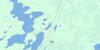
063G12 Bracken Lake Topo Map
To view this map, mouse over the map preview on the right.
You can also download this topo map for free:
063G12 Bracken Lake high-resolution topo map image.
Maps for the Bracken Lake topo map sheet 063G12 at 1:50,000 scale are also available in these versions:
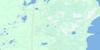
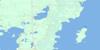
Bracken Lake Surrounding Area Topo Maps
 |
 |
 |
 |
 |
 |
 |
|
 |
 |
||
 |
 |
 |
© Department of Natural Resources Canada. All rights reserved.
Bracken Lake Gazetteer
The following places can be found on topographic map sheet 063G12 Bracken Lake:
Bracken Lake Topo Map: Lakes
Bracken LakeCedar Lake
Clearwater Lake
Griffin Lake
Kanepetakayo Lakes
Kawakwunwit Lake
Kawisapiskeetak Lake
Moose Lake
Mostosis Lake
Norris Lake
South Moose Lake
Bracken Lake Topo Map: Rivers
Bracken Creek
© Department of Natural Resources Canada. All rights reserved.
