Bridge Lake Topo Map Online
Download Free Topo Map Sheet 092P07 at 1:50,000 scale
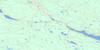
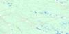
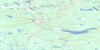
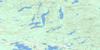
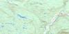
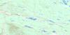
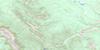
092P07 Bridge Lake Topo Map
To view this map, mouse over the map preview on the right.
You can also download this topo map for free:
092P07 Bridge Lake high-resolution topo map image.
Maps for the Bridge Lake topo map sheet 092P07 at 1:50,000 scale are also available in these versions:
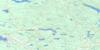
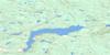
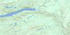
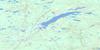
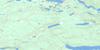
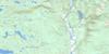
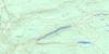
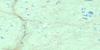
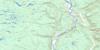
Bridge Lake Surrounding Area Topo Maps
 |
 |
 |
 |
 |
 |
 |
 |
 |
 |
 |
 |
 |
 |
 |
 |
© Department of Natural Resources Canada. All rights reserved.
Bridge Lake Gazetteer
The following places can be found on topographic map sheet 092P07 Bridge Lake:
Bridge Lake Topo Map: Geographical areas
InterlakesBridge Lake Topo Map: Islands
Long IslandBridge Lake Topo Map: Lakes
Bandello LakeBirch Lake
Bonaparte Lake
Bridge Lake
Burn Lake
Campeau Lake
Crescent Lake
Crystal Lake
Dogskin Lake
Eagan Lake
East Twin Lake
Eugene Lake
Hansen Lake
Henley Lake
Knight Lake
Lac des Roches
Little Muskrat Lake
Little Scot Lake
Machete Lake
Macheté Lake
Montana Lake
Muskrat Lake
No. 1 Lake
No. 2 Lake
Peel Lake
Porter Lake
Raspberry Lake
Rutherford Lake
Sharpe Lake
Sheridan Lake
Spectacle Lake
Tobe Lake
Tortoise Lake
Webb Lakes
West Twin Lake
Whitley Lake
Young Lake
Bridge Lake Topo Map: Mountains
Bonaparte HillsBridge Lake Topo Map: Major municipal/district area - major agglomerations
Cariboo Regional DistrictBridge Lake Topo Map: Conservation areas
Bridge Lake Centennial ParkBridge Lake Park
Bridge Lake Topo Map: Plains
Fraser PlateauInterior Plateau
Kukwaus Plateau
Thompson Plateau
Bridge Lake Topo Map: Rivers
Brown CreekCampeau Creek
Dickey Creek
Eastwood Creek
Eugene Creek
Graham Creek
Hammer Creek
Hooligan Creek
Machete Creek
Macheté Creek
McDonald Creek
Montana Creek
Mooney Creek
Orren Creek
Price Creek
Rayfield River
Scot Creek
Simmons Creek
Watch Creek
Whitley Creek
Wilson Creek
Bridge Lake Topo Map: Shoals
Stack RocksBridge Lake Topo Map: Unincorporated areas
Bridge LakeNorth Bonaparte

© Department of Natural Resources Canada. All rights reserved.
092P Related Maps:
092P Bonaparte Lake092P01 Louis Creek
092P02 Criss Creek
092P03 Loon Lake
092P04 Clinton
092P05 Jesmond
092P06 Green Lake
092P07 Bridge Lake
092P08 Chu Chua Creek
092P09 Clearwater
092P10 Deka Lake
092P11 100 Mile House
092P12 Gustafsen Lake
092P13 Chimney Lake
092P14 Lac La Hache
092P15 Canim Lake
092P16 Mahood Lake
