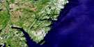
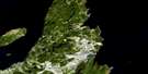
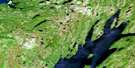
Harbour Grace Satellite Image Map
Download Free Aerial Photo 001N11 at 1:50,000 scale
Harbour Grace Satellite Imagery
To view this satellite map, mouse over the air photo on the right.
You can also download this satellite image map for free:
001N11 Harbour Grace high-resolution satellite image map.
Maps for the Harbour Grace aerial map sheet 001N11 at 1:50,000 scale are also available in these versions:
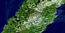
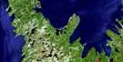
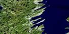
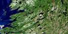
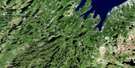
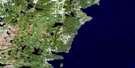
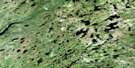
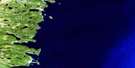
Harbour Grace Surrounding Area Aerial Photo Maps
 |
 |
 |
|
 |
 |
 |
|
 |
 |
 |
|
 |
 |
 |
© Department of Natural Resources Canada. All rights reserved.
Harbour Grace Gazetteer
The following places can be found on satellite image map 001N11 Harbour Grace:
Harbour Grace Satellite Image: Bays
Bachelors CoveBack Bell Cove
Back Cove
Back Cove
Back Dock
Ballast Cove
Battery Cove
Bay de Grave
Bay Roberts
Bay Roberts Harbour
Beach Cove
Beachy Cove
Beachy Cove
Bears Cove
Bears Cove
Bell Cove
Betsys Cove
Big Cove
Bishops Cove
Bishop's Cove
Black Gulch
Black Hole
Blow Me Down Cove
Bread Cove
Brigus Bay
Brigus Cove
Bristol's Hope Cove
Broad Cove
Broad Cove
Bryants Cove
Buffy Cove
Bull Cove
Burnt Head Cove
Cakes Cove
Cannon Cove
Caplin Cove
Caplin Cove
Carbonear Bay
Cavendish Bay
Chimney Cove
Clapper Cove
Coadys Cove
Colliers Bay
Conception Bay
Connellys Cove
Cook Room
Cookroom Cove
Cranes Cove
Crockers Cove
Crows Gulch
Cupids Cove
Curtains Cove
Dark Hole
Deep Gulch
Docklock Cove
Flat Rock Cove
French Cove
Frenchs Cove
Freshwater Cove
Freshwater Cove
Frog Marsh Cove
Front Bell Cove
Gallows Cove
Garmons Gulch
Georges Cove
Goats Cove
God Almighty Cove
Golden Cup
Gordons Cove
Gradys Cove
Granddaddy Gulch
Grates Cove
Grattons Cove
Great Cove
Great Cove
Grebe Cove
Greenland
Gun Cove
Harbour Grace
Hawks Nest
Hayes Cove
Hibbs Hole
Horseshoe Cove
Husseys Cove
Island Cove
Jugglers Cove
Kelligrews Gut
Lears Cove
Long Harry Cove
Lovers Leap
Lower Back Cove
Lower Cove
Lower Long Cove
Mad Rock Cove
Malones Cove
Martins Cove
Maul Ashes Hole
Mercers Cove
Middle Bight
Mint Cove
Mouse Hole
North Cove
Northern Cove
Parsons Cove
Parsons Cove
Patricks Pier
Patty O'Keefes Cove
Pea Cove
Pick Eyes Cove
Pikes Cove
Pine Cove
Pippys Dock
Quiltys Cove
Red Cliff Cove
Rocky Cove
Rolling Cove
Salmon Cove
Sandy Cove
Sandy Cove
Santlers Cove
Sharks Cove
Ship Cove
Ship Cove
Shoe Cove
Skanes Cove
South West Bay
Spaniard's Bay
Spoon Cove
Stage Cove
Stake Maul Gulch
Taylors Cove
Taylors Gulch
The Bight
Turks Gut
Upper Back Cove
Upper Cove
Upper Island Cove
Upper Long Cove
Whalens Cove
Whiteway Bay
Whiteway Harbour
Woody Island Cove
Harbour Grace Satellite Image: Beaches
Courages BeachEaster Beach
Finky Beach
Flynns Dock
Kings Beach
Little Beach
Little Beach
Long Beach
Long Beach
Long Beach
Long Beach
Pynns Beach
Short Beach
The Backside
The Scrape
Harbour Grace Satellite Image: Capes
Avalon PeninsulaBartletts Head
Battery Head
Bay Roberts Point
Beachy Cove Point
Bears Cove Point
Bears Point
Bens Head
Big Head
Big Island
Bishops Point
Black Point
Blow Me Down Head
Brigus Head
Bryants Cove Point
Bulls Head
Burgess Point
Burnt Head
Burnt Point
Caplin Cove Point
Coley's Point
Colliers Point
Coopers Head
Cranberry Point
Crockers Point
Cronins Head
Davies Head
Dawe Head
Dawes Head
Deep Water Point
Feather Point
Feather Point
Flag Staff
Foxtrap Head
Gallows Cove Point
Grassey Point
Great Head
Green Head
Green Head
Green Point
Gull Head
Jersey
Jones Head
Jugglers Point
Kelligrews Point
Lassy Point
Mad Point
Moses Point
Mosquito Point
Net Point
Newmans Point
North Head
Norther Point
Old Sow Point
Peters Finger
Point of Beach
Sailing Point
Salmon Cove Point
Seal Head
Sharks Head
Ship Cove Point
Ship Head
Shoal Point
Shoal Point
Solomon Earles Point
Sopers Point
South Point
Souther Point
Spaniards Bay Point
Spare Point
Spectacle Head
Tarrys Point
Taylors Head
The Arch
The Bachelor
The Head
The Point
Turks Head
Western Point
Windy Point
Woody Point
Harbour Grace Satellite Image: Channels
Dully FareSouther Fare
Harbour Grace Satellite Image: Cliffs
Darbys ArmDarbys Leg
North Head
Snorters Head
The Gates
Harbour Grace Satellite Image: Forests
Sheppards First GroveSheppards Second Grove
The Grove
Uncle Dicks Grove
Yetmans Grove
Harbour Grace Satellite Image: Islands
Bakers IslandBell Island
Bosun Island
Carbonear Island
Coadys Island
Fergus Island
Freshwater Island
Harbour Grace Islands
Hibbs Cove Island
Jugglers Cove Island
Kellys Island
Mollys Island
Pea Island
Port de Grave Island
Round Island
Sculpin Island
Spracklins Island
Harbour Grace Satellite Image: Lakes
Andersons PondArnies Pond
Backside Pond
Banky Pond
Bannerman Lake
Bar Pond
Barrys Pond
Bartletts Gully
Bats Pond
Battens Pond
Beaver Pond
Beaver Pond
Beaver Pond
Beaver Pond
Beaver Pond
Bell Pond
Bell Pond
Big Gull Pond
Big Gully
Big Island Pond
Big Pond
Big Pond
Big Round Pond
Big Suttons Pond
Bishops Gully
Bishops Pond
Black Duck Pond
Black Duck Pond
Black Duck Pond
Bog Pond
Bowes Long Pond
Bowes Round Pond
Brazils Pond
Bread and Cheese Cove Pond
Bridges Pond
Brigus Long Pond
Bryants Cove Pond
Bull Pond
Camels Back Pond
Camels Back Pond
Campbells Gully
Carbonear Long Pond
Carbonear Pond
Cat Hill Pond
Cavendish Pond
Chalkers Pond
Circle Pond
Clarke's Beach Pond
Clarke's Pond
Coopers Pond
Cottage Pond
Country Pond
Cow Pond
Crooked Pond
Cross Pond
Cuff Pond
Cupids Big Pond
Cupids Pond
Darby Queen Pond
Deep Hole
Dennys Pond
Dinnys Pond
Drakes Pond
Easter Steady Pond
Eastern Island Pond
Eastern Steady Pond
First Gully
First Pond
First Pond
First Pond
First Pond on the Barrens
Flings Big Pond
Flings Long Pond
Four Corner Pond
Fourth Pond
Fox Pond
Fox Pond
Frog Marsh Pond
Giles Pond
Goose Pond
Grassy Gullies
Grassy Pond
Greens Gully
Gull Pond
Gull Pond
Gull Pond
Gully Garden
Gunners Pond
Harbour Pond
Hat Pond
Hay Bag Pond
Hoskins Pond
Hunts Gully
Inside Island Cove Pond
Island Cove Pond
Island Pond
Island Pond
Island Pond
Island Pond Gully
Jack Lears Gully
James Gully
Jimmy Rowes Pond
John MacLeans Pond
John Williams Pond
Kellys Pond
Kings Pond
Lady Lake
Little Coopers Pond
Little Flings Pond
Little Gull Pond
Little Island Pond
Little Pond
Little Pond
Little Rinders Pond
Little Rocky Pond
London Pond
Long Beach Pond
Long Beach Pond
Long Island Pond
Long Pond
Long Pond
Long Pond
Long Pond
Loo Pond
Lower Valley Pond
Luthers Gullies
Maidens Ponds
Mattys Pond
McCarthys Pond
Mint Cove Pond
Mosquito Pond
Muddy Gully
Muddy Hole
Mussel Bed Pond
Neddie Smiths Pond
Neddie Smith's Pond
Nine Island Pond
Normans Pond
Normans Pond
Northeast Gully
Northern Cove Pond
Ocean Pond
Outside Island Cove Pond
Peddles Pond
Pegs Pond
Pikes Pond
Pitchers Pond
Red Rock Pond
Rinders Pond
Riverhead Long Pond
Rocky Gully
Rocky Gully
Rocky Pond
Rocky Pond
Rocky Pond
Rocky Pond
Rocky Pond
Rossiters Pond
Round Pond
Round Pond
Round Pond
Round Pond
Saltwater Pond
Saltwater Pond
Saw Pit Gully
Scotch Pond
Second Pond
Second Pond
Second Pond
Seymours Gullies
Shanahans Gully
Shearstown Pond
Sheas Gully
Ship Cove Pond
Sloans Gully
Snows Pond
South Pond
Spider Pond
Spruce Pond
Spruce Pond
Suttons Gullies
Suttons Pond
Sweetwater Pond
The Bower
The Coish
The Gullies
The Pond that Feeds the Brook
The Ponds
The Sisters
Third Pond
Third Pond
Third Pond
Three Aunt Kates
Three Corner Pond
Three Corner Pond
Tickle Ponds
Tilt Hill Gully
Tilton Pond
Tuckers Gully
Upper Duck Pond
Upper Rocky Pond
Valley Ponds
Warm Gullies
Webbers Pond
Western Island Pond
White Hill Pond
Whitewood Pond
Harbour Grace Satellite Image: Marine navigation features
The QuayHarbour Grace Satellite Image: Mountains
Alderberry HillBald Hill
Biddys Mount
Big Hill
Big Lookout
Black Point Hill
Bob Dawes Hill
Brazils Hill
Brennans Hill
Brigus Highlands
Brigus Lookout
Bulger Rock
Bull Bird Hill
Bull Birds Hill
Camels Back
Cat Hills
Church Hill
Clarkes Hill
Corbetts Hill
Cow Hill
Crow Hill
Crows Nest
Cupids Hill
Dicks Hill
Dinner Hill
Dock Mountain
Flag Staff Hill
Flats
Flour Barrel Hill
Foleys Hill
Foxes Rocks
Frog Marsh Hills
Gibbet Hill
Greens Hill
Hardy Hill
Harrys Hill
Highlands
Jackies Pinch
Jewels Hill
Jimmy Rowes Hill
Little Mash Hill
Long Point Hill
Lower Hawke Hill
Lower Hawks Nest
Markys Hill
Maul Tree Hill
Mountain Jack
Muddy Hole Hill
Nut Tree
Otter Holes
Partridgeberry Hill
Patsy Bryants Hill
Peak of the Reef
Riverhead Hills
Robert Hill
Roberts Lookout
Rocky Hills
Rods Hill
Saddle Hill
Salmon Cove Ridge
Saw Pit Hill
Seal Lookout
Sheppards Hill
Shoal Harbour Hill
Skating Rock
Snows Ridge
Spruce Hill
The Gully Nap
The Indian
The Lookout
The Mountain
The Mountain
The Pond Nap
The Ridge
The Scrape
The Tolts
The Turfy Spot
Thumb Peak
Tilt Hill
Tilts Hill
Twin Peak
Uncle Nats Hill
Upper Hawke Hill
Upper Hawks Nest
Vinegar Hill
Vinegar Hill
Welch Hill
Harbour Grace Satellite Image: Major municipal/district area - major agglomerations
St. John's Metropolitan AreaHarbour Grace Satellite Image: Conservation areas
Backside Pond Provincial ParkHawthorne Cottage National Historic Site of Canada
Lieu historique national du Canada du Cottage-Hawthorne
Newfoundland T'Railway Provincial Park
Harbour Grace Satellite Image: Plains
The PlainHarbour Grace Satellite Image: Rivers
Andersons BrookApses Brook
Bannerman River
Beaver Pond Brook
Bell Pond Brook
Bowes Brook
Brigus North Brook
Cow Pond Brook
Doyles Brook
Dram Cup
East Brook
Fairy Marsh Brook
Goulds Brook
Gull Pond Brook
Horse Brook
Island Pond Brook
Kelligrews River
Lambes Brook
Long Pond Brook
Mill Brook
Mosquito Brook
North River
Pitchers Pond Brook
Powells Brook
Rattling Brook
Rodgers Brook
Running Brook
Ryans Brook
Shearstown Brook
South River
South River
South West Brook
West Brook
Harbour Grace Satellite Image: Road features
The KlondikeHarbour Grace Satellite Image: Shoals
Bell RockBettlers Rock
Boil Rocks
Boulder Bank
Bull Rock
Drummers Rock
Drying Rocks
Drying Rocks
Eastern Rock
Haypook
Little Easter Rock
Long Harry Rock
Mad Rocks
Middle Rock
Mugford Rock
My Lord
Northeast Rock
Old Sow Rock
Ragged Rocks
Salmon Rock
Salvage Rock
Sandy Ground
Saucy Joe Rock
Shag Rock
Sisters
Sopers Rock
Southern Rock
Southern Rocks
Stage Cove Rock
Stage Rock
Sunken Rocks
The Bar
The Bell
The Clapper
The Mare and Foal
The Sunker
The Three Sisters
Tuckers Mill
White Rock
White Rock
Harbour Grace Satellite Image: Towns
Bay RobertsBishop's Cove
Brigus
Bryant's Cove
Carbonear
Clarke's Beach
Conception Bay South
Conception Harbour
Cupids
Hant's Harbour
Harbour Grace
North River
South River
Spaniard's Bay
Spaniard's Bay-Tilton
Upper Island Cove
Whiteway
Harbour Grace Satellite Image: Unincorporated areas
BareneedBeachy Cove
Birch Hills
Bishops Beach
Black Duck Pond
Blow Me Down
Brigus
Brigus Gullies
Bristol's Hope
Bryants Cove
Burnt Head
Butlerville
Cavendish
Coley's Point
Coley's Point South
Cooperage
Country Road
Crockers Cove
Cupids Crossing
Eastern Corner
Emerald Vale
Frenchs Cove
Freshwater
Frog Marsh
Georgetown
Goddenville
Goulds
Greenland
Green's Harbour
Gullies
Gullies
Halls Town
Harbour Grace (Southside)
Harbour Grace South
Hibbs Cove
Juniper Stump
Kelligrews
Makinson
Makinsons
Mercer's Cove
North Valley
North West Arm
Otterbury
Otterbury
Parsonsville
Parsonville
Pick Eyes
Port de Grave
Riverhead
Riverhead
Roaches Line
Salmon Cove
Sandy Beach
Sharks Cove
Shearstown
Ship Cove
Southside
Spoon Cove
Springfield
Stevensons Village
The Battery
The Broads
The Dock
The Motion
The Thicket
Tilton
Harbour Grace Satellite Image: Valleys
Devils HoleHarbour Grace Satellite Image: Low vegetation
Bakeapple MarshBell Pond Marsh
Black Mash
Fairy Marsh
Frog Marsh
Grandma Gosses Marsh
Hay House Marsh
Highland Marsh
Juniper Marsh
Lowlands
Mains Marsh
Sooleys Marsh
The Pasture
Yellow Marsh
Harbour Grace Satellite Image: Villages
Hibbs Hole
© Department of Natural Resources Canada. All rights reserved.
