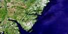
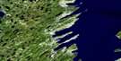
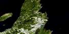
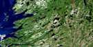
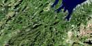
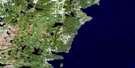
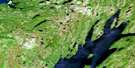
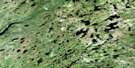
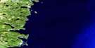
Placentia Satellite Image Map
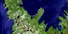
Download Free Aerial Photo 001N04 at 1:50,000 scale
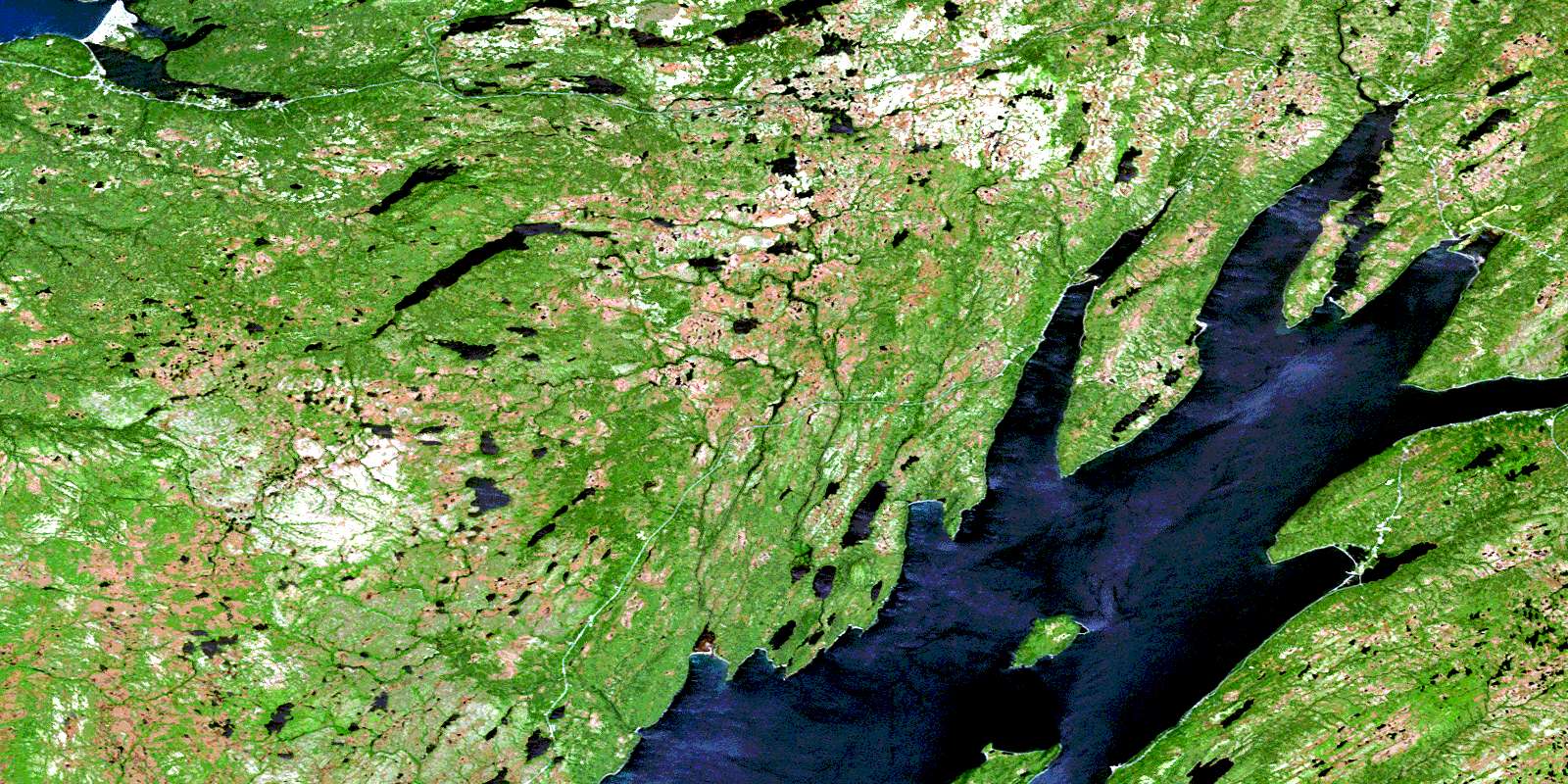
Placentia Satellite Imagery
To view this satellite map, mouse over the air photo on the right.
You can also download this satellite image map for free:
001N04 Placentia high-resolution satellite image map.
Maps for the Placentia aerial map sheet 001N04 at 1:50,000 scale are also available in these versions:
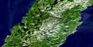
Placentia Surrounding Area Aerial Photo Maps
 |
 |
 |
|
 |
 |
 |
|
 |
 |
 |
|
 |
 |
 |
© Department of Natural Resources Canada. All rights reserved.
Placentia Gazetteer
The following places can be found on satellite image map 001N04 Placentia:
Placentia Satellite Image: Bays
Allans CoveBack Cove
Back Cove
Bear Cove
Bettys Cove
Big Head Cove
Big Jonas Cove
Big Judy Cove
Black Cove
Block House Cove
Boat Cove
Colinet Arm
Colinet Harbour
Cows Face
Deadmans Cove
Dog Cove
Duggans Gut
Foals Bridge
Gleasons Cove
Gull Rock Cove
Harricott Bay
Hawks Cove
Hazes Brook
Ice House Cove
Joe Stones Cove
John's Pond Cove
Kings Cove
Little Jonas Cove
Little Judy Cove
Little Red Cove
Little Salmonier Cove
Lotties Cove
Macdonald Cove
Macdonalds Cove
Mussel Pond Cove
Neils Cove
North Harbour
Placentia Harbour
Placentia Road
Point Cove
Red Cove
Regina Cove
Salmonier Arm
Sandy Coves
Snack Cove
Southeast Arm
St. Mary's Bay
Swans
Taylors Cove
Tickles Bight
Tobins Cove
Wild Cove
Placentia Satellite Image: Beaches
Admirals BeachBrewley
Cape Dog Strand
Dunphys Beach
Gregorys Beach
Harricott Beach
Horsehead Beach
Long Beach
Mussel Beach
North Harbour Beach
Placentia Beach
Ryans Beach
The Strand
Tickles Beach
Placentia Satellite Image: Capes
Admirals Beach SpitAvalon Peninsula
Back Point
Barachois Point
Bear Head
Big Head
Black Point
Block House
Bluff Head
Bushy Head
Cape Dog
Cross Point
Dalton Point
Davis Point
Davis Point
Frazer Point
Grassy Head
Gregorys Point
Harbour Path Point
Harricott Point
Horsehead Point
Johnny Dinns Point
Jonas Point
Kings Point
Little Salmonier Point
Long Point
McGuires Head
North Harbour Point
Northern Point
Patrick Point
Pennys Poind
Pennys Point
Pinch Point
Pinchgut Point
Point of Flower
Quigleys Point
Red Point
Rocky Point
Rocky River Point
Ryan's Point
Salmonier Point
Shanahans Point
Stake Point
Taylors Cove Point
Tickle Point
Tobins Point
Town Point
Placentia Satellite Image: Channels
Big GutColinet Passage
Harricott Gut
Little Gut
Little Gut
Middle Gut
Pinchgut Tickle
The Passage
Tickles Gut
Placentia Satellite Image: Falls
Beaver FallsClam River Falls
Colinet River Falls
Rocky River Falls
Placentia Satellite Image: Forests
Hovel WoodsMountain Woods
Powers Knap
Walshs Woods
Placentia Satellite Image: Islands
Bird IslandGreat Colinet Island
Gull Island
Half Island
Little Colinet Island
Long Island
Long Islands
Pea Island
Petticoat Island
Philips Island
Pinchgut Island
Pond Head Island
Salmon Island
Tickle Island
Verrans Island
Woody Island
Placentia Satellite Image: Lakes
Adrians PondsArts Pond
Barasway Ponds
Bear Cove Pond
Beaver Gullies
Beaver Pond
Beaver Pond
Beaver Pond
Beaver Ponds
Big Barachois
Big Goat Pond
Big Hovel Pond
Big Kinowinch Pond
Big Loon Pond
Big Weeks Pond
Birch Hill Gully
Black Duck Gullies
Black Duck Gullies
Black Duck Ponds
Black Hole
Brians Gully
Brians Pond
Broader Pond
Careens Pond
Cataracts Pond
Chimney Pond
Clam Gullies
Collins Pond
Collins Ponds
Connaughtman Pond
Conways Pond
Coopers Pond
Crooked Pond
Crossing Place Pond
Davies Pond
Davis Barasway
Deer Pond
Dog Cove Pond
Dry Pond
Duck Pond
Duck Pond
Duck Pond
Duck Pond
Dunphys Pond
East End Gull Pond
Eastern End Ponds
Eastern End Tucks
Elizabeths Gullies
English Pond
Falls Pond
First Barasway
First Hovel Pond
Flinn River Ponds
Fox Pond
Fox Ponds
Geralds Pond
Goose Pond
Goose Pond
Great Gull Pond
Green Island Pond
Green Rub Pond
Grey Rock Pond
Gull Pond
Gull Pond
Gull Pond
Gull Pond
Gull Pond
Half Island Pond
Halfway Rock Ponds
Hanrahans Pond
Harricott Long Pond
Harricott Pond
Harrigans Ponds
Harveys Big Pond
Harveys Pond
Hat Pond
Hatchet Ponds
Hawkeys Pond
Hay Ponds
Hay Ponds
Hickeys Pond
Hidden Pond
High Bank Pond
Hill Pond
Hynes Pond
Indian Ponds
Inside Ridge Pond
Island Pond
Jay Ponds
John's Pond
Kellys Pond
Lily Ponds
Little Barachois
Little Duck Pond
Little Goat Pond
Little Loon Pond
Little Mussel Pond
Lonesome Ponds
Lookout Pond
Lookout Pond
Lookout Ponds
Mag Cove
Mash Pond
McGraths Pond
McGuires Barasway
Middle Lead Pond
Mountain Pond
Murphys Pond
Murrays Pond
Mussel Pond
North Harbour Pond
O'Keefes Pond
Old Mill Barasway
Otter Pond
Otter Pond
Outside Ridge Pond
Powers Pond
Prisoners Pond
Prowse Gully
Pup Gully Pond
Reillys Gullies
Reynolds Pond
Rocky Island Pond
Rocky Pond
Rocky Pond
Rocky Ponds
Salmon Brook Pond
Saltwater Pond
Sammys Marsh Pond
Scotts Ponds
Second Barasway
Sedges Ponds
Sedgy Pond
Shoal Bay Pond
Shoal Pond
Skin Cabin Pond
Smiths Pond
Snack Cove Pond
Sock Pond
Southeast Pond
St. Josephs Pond
Stones Pond
The Deeps
The Hill Ponds
The Two Ponds
Tickles Gut Barasway
Tobins Pond
Trappers Pond
Trembletts Pond
Trout Pond
Trout Pond
Turfy Pond
Twin Ponds
Twin Ponds
Uncle Johnnys Barasway
Wallaces Gullies
White Rocky Pond
White Rocky Pond
Placentia Satellite Image: Mountains
Barasway Dry HillBarasways Sugarloaf
Beaver Pond Hills
Bingons Hill
Block House Hill
Bowring Ridge
Brimstone Head
Burnt Hill
Burnt Hills
Castle
Castle Ridge
Davies Lookout
Dixon Hill
Dixons Hill
East Pinnacle
Eastern Pinnacle
Fox Burrow
Grey Rock
Harveys Hill
Jarvis Peak
Kettles Hill
Knock Hour Hill
Little Burnt Ridge
Little Ganderose
Mid Pinnacle
Mount Pleasant
Mussel Pond Point
Mussel Pond Point
North Harbour Lookout
North Harbour Point
Partridgeberry Hills
Prowses Hill
Ridge Hill
Ryans Hill
Sawyers Hill
Sepoy Hill
Shoal Bay Hill
Southeast Mountain
St. Mary's Sugarloaf
The Big Ridge
The Chimneys
The Lookout
The Lookouts
West Pinnacle
Western Pinnacle
White Hovel Hill
Placentia Satellite Image: Conservation areas
Cataracts Provincial ParkPlacentia Satellite Image: Rivers
Back RiverBaldwins Brook
Barasway Brook
Bear Cove River
Beaver Pond Gully
Beaver River
Big Barachois River
Big Rock Lead
Black Duck Gully
Black Duck River
Branch River
Burnt Hill River
Cape Dog River
Cataract Brook
Cataract River
Clam River
Colinet River
Collins Brook
Connaughtmans Gully
Corner River
Drooks River
Duggans River
Eastern Pinnacle Gully
Flinn River
Glennons Cove River
Green River
Hare Hill Gully
Harrigans Brook
Hay Ponds River
Island Pond River
Juniper Gully
Little Barachois River
Little Barachois River
Little Barachois River
Little Barasway River
Little Harricott River
Little Salmonier River
Looneys River
Lower River
Mall Bay Brook
Mannys River
McGuires River
Mid Pinnacle Gully
Middle Brook
Middle Lead
Mitchells Brook
Murrays Brook
Mussel Pond River
Neddies Path River
North Brook
North Harbour River
O'Keefes Brook
Otter Rub
Rattling Brook
Rocky River
Saddle Brook
Salmon Brook
Seal Rocks River
Shoal Bay River
Smelt Brook
Solomons River
Southeast River
St. Mary's Sugar Brook
Trembletts River
Trout River
Walshs Woods Brook
Watering Place
Weeks Pond Brook
Western Pinnacle Gully
Placentia Satellite Image: River features
Fork PoolFour Mile Pool
Salmon Hole
Placentia Satellite Image: Shoals
Back ShoalBear Cove Sunker
Johns Shoal
Lansecan Rocks
The Gullies
Placentia Satellite Image: Towns
Admirals BeachAdmiral's Beach
Colinet
Mount Carmel-Mitchells Brook-St. Catherines
Mount Carmel-Mitchells Brook-St. Catherine's
Placentia
St. Joseph's
Placentia Satellite Image: Unincorporated areas
Cape DogHarricott
John's Pond
Mitchells Brook
North Harbour
North Harbour South
O'Donnells
Point Verde
Reginaville
Southeast Placentia
Tickles
Placentia Satellite Image: Valleys
Moriaritys GulchPlacentia Satellite Image: Low vegetation
Beaver MarshesBurnt Knap
Collins Pond Marsh
Cranberry Marsh
Deer Horn Marsh
Fureys March
Fureys Marsh
Ganderose March
Ganderose Marsh
Harricott Flats
Harricott Marsh
High Marsh
Kinowinch Marsh
Mall Bay Bottom
Middle Lead
Murray Marsh
Murrays Marsh
Mussel Pond Bottom
Sammys Marsh
Skin Cabin Marsh
The Flats
The Trenches
Yellow Marsh
© Department of Natural Resources Canada. All rights reserved.
